Tell Madaba Archaeological Project
| Project History |
|
The modern archaeological exploration of Madaba commenced in the 1930s with Nelson Glueck's monumental survey of Eastern Palestine, and the start of the Franciscan excavations at Siyagha-Mount Nebo under the leadership of S.J. Saller and B. Bagatti. Saller and Bagatti quickly took an interest in the mosaics of Madaba, and published studies of two mosaic pavements, both of which are now part of the Madaba Archaeological Museum. In 1948, workers digging the foundations for a new house stumbled upon a Late Bronze-Early Iron Age tomb, furnishing the first archaeological evidence of pre-Roman occupation at the site. The ensuing decades witnessed a steady flow of salvage excavations and restoration projects conducted on behalf of the Jordanian Department of Antiquities, and for the most part concentrated in the lower city of classical times. A rare exception, in 1967, saw the discovery of a second Iron Age tomb, this one on the southeastern edge of the modern town. The 1970s and 1980s witnessed the large-scale excavations of several Byzantine churches and their mosaic pavements, including the Cathedral Church complex, the Salayta Church, the Church of the Prophet Elijah and the Church of the Virgin. Earth removal along the western slope of the acropolis in 1980 exposed a series of barrel-vaulted shops paved with mosaic floors, adding still further to our knowledge of the classical town. With the exception of the two Iron Age tombs, the extensive clearing operations of the post-WW II era have focused exclusively on the remains of the classical town, leaving the pre-Roman occupational history of Madaba untouched. The large-scale excavations of the 1970's and 1980's created an acute need for consolidation and preservation in Madaba, and, in 1991, prompted the creation of a program to train skilled local mosaic conservators. Largely as a result of this initiative, a multi-faceted joint project was conceived by the Ministry of Tourism of Jordan and the United States Agency for International Development (USAID) to develop an archaeological park that would preserve these archaeological treasures, and render them more accessible to the general public. In 1993, under a grant from USAID, the American Center of Oriental Research (ACOR) undertook a base-line study of the historic areas of Madaba with the aim of creating a database that could facilitate future research and development efforts in Madaba.
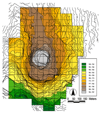
The Tell Madaba Archaeological Project (TMAP) was inaugurated in 1995 with the express purpose of assembling an "urban" sample as part of a larger, ongoing regional research effort. A preliminary field season, funded by the National Geographic Society, was conducted in 1996 to further define the extent of the tell, and assess the feasibility of carrying out large scale excavations at the site. A digitized map (at 1:1250 scale) of the urban core of Madaba, created during the 1993 survey using Geographic Information Systems (GIS) software technology (ArcInfo), was used to construct a topographic relief map that clearly and precisely defined the extent of the ancient mounded tell (approximately 16 ha in area at the base and 9 ha at the summit), now largely hidden beneath the buildup of the modern town. The effort succeeded in identifying specific areas of the site that were accessible to archaeological exploration. Equally important, use of this GIS technology have enabled the results of the 1996 field season, and those of future field seasons, to be integrated in a single relational database for the entire site. The 1996 field season also included excavations on the southeastern slope of the site (Field A), and resulted in an 8 m vertical profile of the existing stratigraphy of the lower tell. The earliest occupational levels reached in Field A revealed a settlement history that began in the late EB I/II period (ca. 3100 B.C.E.), just prior to the onset of the urban phase of the EBA. Superimposed on the EBA levels were a series of later Iron Age trash deposits. Ceramic evidence recovered from these deposits indicate human activity occurred on the tell during much of the intervening period, suggesting a relatively continuous Bronze and Iron Age occupational sequence. The Field A excavations also revealed some of the richness of the Iron Age levels at Madaba. Preserved in the secondary context of these trash deposits were a wealth of ceramic, botanical, faunal, and metallurgical material, as well as jewelry, a number of seals and seal impressions, and other small finds. In addition to the excavations in Field A, a mapping survey was conducted on the western slope of the upper mound (or acropolis), where extensive architectural remains were visible. Following a study season in the spring and summer of 1997, full-scale excavations were initiated in 1998 along the western slope of the upper mound (designated Fields B and C). These excavations were continued and expanded in 1999 and 2000. In Field B, they have succeeded in uncovering a six-phase stratified sequence spanning four broad cultural horizons tentatively dated to the Late Ottoman (Late 19th Century and later), Early Roman/Nabataean (1st Century B.C.E. to 1st Century A.D.), Late Hellenistic (2nd-1st Centuries B.C.E.), and Iron IIB (9th-8/7th Centuries B.C.E.) periods. The Field C excavations, meanwhile, have uncovered the remains of a large residential complex, preserved in two architectural phases that span the Late Byzantine/Early Islamic transition (6th-7th/8th Centuries C.E.). In 2001, fieldwork was devoted primarily towards the consolidation and restoration of this complex. Finally, during the 2002 field season, excavations targeted the extensive Iron II remains in Field B, and sought to complete the exposure of the monumental Late Byzantine/Early Islamic Complex in Field C. The 2002 field season marked the end of Phase I of the Tell Madaba Archaeological Project. |
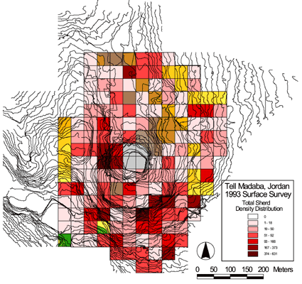 As part of this effort, the principal investigator conducted an intensive surface survey of the urban core of ancient Madaba. A grid system set at 50 meter intervals was devised utilizing a topographic relief map (at 1:1250 scale) to facilitate systematic collection over the entire survey universe, an area of approximately 40 hectares. The survey was conducted in 1993 over a 12-day period between March 27 and April 10. In all, 166 squares were surveyed, resulting in coverage of an area totaling 415,000 square meters, or approximately 42 hectares, with open and uninhabited space accounting for about 25% of this total. The results of this survey established the broad spatial dimensions and settlement history of the site, and identified it as one of the largest, if not the largest, settlements in the region.