Click below to see archival footage of excavations at Tell Madaba in 2002.
INTRODUCTION:
The Tall Mādabā Archaeological Project (TMAP) represents part of a broader, regional research effort that seeks to test prevailing theories about the development of centralized institutions and the rise of early state-ordered societies in the southern Levant. Drawing on the historical perspective that the archaeological record represents, this effort seeks to achieve the following research objectives:
Document the changing subsistence strategies of specific communities over time
Identify the underlying social factors that may have influenced decision making processes
Assess the impact adaptive responses have had on the fragile balance critical to maintaining ecological equilibrium--and long term viability--in a marginal, or transitional, environment.
Given the current concern in Jordanfor developing, or re-introducing, economic strategies that conserve scarce cultural and natural resources, these research objectives address issues of contemporary relevance and importance.
Within this broader research framework, the Tall Mādabā excavations were initiated for the specific purpose of gathering archaeological data from the presumed urban center of a regional settlement network for comparison withexisting data sets from comparable contexts (e.g. domestic/residential, administrative/public, etc.) at contemporary rural village sites in the region. In the modern Middle East, with its long history of urbanism, the consequences of urban continuity present a daunting challenge to this type of archaeological research. The city of Mādabā, located 30 km southwest of Ammanamidst the fertile rolling plains of the Central Jordanian Plateau, represents an exceptional example of this phenomenon. Continuing an urban tradition of some 5,000 years, the modern town engulfs the ancient settlement, preserved in the form of a large low-lying tall and acropolis that still forms a visible rise in the town center. Clearly, Mādabā’s historical prominence necessitates a thorough assessment of its role in the long and eventful history of the Central Highlands of Jordan.
The Tall Mādabā excavations were conceived with the goal of pursuing this investigation. By focusing on the central site of Mādabā, the project has been working since 1996 to anchor an emerging regional database, and to facilitate analysis of the changing economic and sociopolitical organization of communities on a regional level. For more detailed descriptions of the project’s research objectives and history, the reader is referred to previous reports submitted to the Department of Antiquities, and to published and forthcoming articles in the Annual of the Department of Antiquities of Jordan.
2002 FIELD SEASON OBJECTIVES:
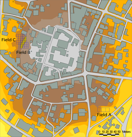
In keeping with the Tall Mādabā Archaeological Project (TMAP) objective to map architecture and assemble quantifiable artifact assemblages for each of the principal phases of occupation at the site, the 2002 field season saw a continuation of the excavations begun in 1998 along the west acropolis (Fields B and C; see Figure 2). The primary objectives of the 2002 TMAP field season, therefore, were
To reopen two units in Field B in order to continue the effort to uncover the Iron Age levels first encountered in 1998
To complete excavations of the monumental Late Byzantine/Early Islamic Complex in Field C. In addition to excavation, time and resources were also devoted to continuing the consolidation and restoration efforts on the Field C building begun during the 1999 field season.
This last objective included both the stabilization of existing walls and standing architecture uncovered by our excavations, and the continuation of a project initiated in 2001 to restore mosaic pavements removed from the site in the early 1980s.
The 2002 season was conducted between July 15 and August 31, with the author continuing as overall Project Director, and Debra Foran handling the daily field operations in her capacity as Assistant Project Director. An archaeological field school for students from the Universityof Toronto was also run in conjunction with the 2002 field season. Click HERE for a slide show featuring the students and their experiences during the 2002 Field School.
** Yazid Elayan served as the Department of Antiquities representative.
FIELD B EXCAVATIONS:
ARCHITECTURE
Excavations have been ongoing in Field B since 1998 (image left), and in that time deposits dating to the Late Ottoman (FP 1), Early Roman/Nabataean (FPs 2 and 3), Late Hellenistic (FPs 4 and 5), and Iron II (FP 6) periods have been exposed (see Figure 3). As stated above, the primary goal of the 2002 season in Field B was to continue excavation of the Iron Age remains first encountered during the 1998 season. To this end, two units (Squares 5M21V3 and 5M21U4) on the northern edge of the previously excavated area, and to the east of the large fortification wall, were reopened.
Square 5M21V3, in the northeastern corner of the excavation area, contained a room with a large pit of stones in the center. During the removal of this pit, a significant amount of Late Hellenistic material was recovered, indicating that it may have been the result of later activity that penetrated down into this Iron Age structure. Once the pit was removed, two surfaces with flat lying pottery, clearly dating to the Iron II period, were discovered. The walls of this room are built of medium-sized unhewn rocks, and most of them are now slumping toward the interior of the room. Toward the end of the season, the upper course of a wall made of considerably larger stone boulders was uncovered underneath these walls. These more substantial remains must date to an earlier phase, and were reused in this later period as foundation walls. The initial excavations in Square 5M21U4, to the west of 5M21V3, concentrated on the removal of a series of ash layers, most probably the result of post-destruction abandonment accumulation. The removal of these deposits exposed more of the inner face of the monumental city wall to the west. Under these ash layers were the remains of a north-south wall with a possible doorway, uncovered in the final days of the field season. The size of the stones used in the construction of this wall indicate that it was most likely associated with the earlier phase walls in Square 5M21V3. Excavations to the east of this wall produced evidence of a substantial destruction layer resulting from an intense fire, with some building materials having become vitrified in the conflagration. Sealed by this destruction layer were three well-preserved tabuns and the remains of a surface (only partially excavated in the final days of the season). All of the ceramic material and associated small finds from this unit dated to the Iron II period.
The Field B excavations, therefore, successfully delineated the well-preserved remains of at least two Field Phases dating to the Iron II (ca. 9th/8th-7th Centuries B.C.E.). However, it is clear that considerable deposits from this important cultural horizon (contemporary with the events described in the Mesha Inscription) still remain unexcavated, and therefore will require further attention in future field seasons of TMAP.
HISTORICAL CONTEXT
Textual sources are unequivocal about the importance of Iron Age Mādabā and the surrounding tableland, which became the scene of a succession of power struggles for control of the strategic north-south transit corridor that transects the region, the so-called King’s Highway, during the Iron II period. The Israelite King David is said to have fought and won a pitched battle against a coalition of Aramaeans and Ammonites in the vicinity of Mādabā, or Medeba as it was then called, early in the 10th Century B.C.E. (I Chronicles 19:7ff; cf. II Samuel 10). According to the Mesha Inscription, Mādabā was still under Israelite control (“the house of Omri”) when Mesha captured (lines 7-8) and rebuilt the town (line 30) along with a series of other cities on the tableland in the mid to late 9th Century B.C.E. (either during or shortly after the reign of Ahab, the son of Omri). The region would appear to have remained under Moabite control until the end of the Iron Age, as Mādabā is listed with other Moabite cities in an oracle in Isaiah (15:2) forecasting the devastation of Moab.
The 1993 survey of Mādabā supports the view of a flourishing settlement during the Iron II period, with the distribution of surface sherds indicating a site between 13 and 16 ha in size, easily making it one of the largest Iron II sites in Jordan. The existence of Iron II deposits in Fields A and B, as well as adjacent to the Church of the Prophet Elijah in the ArchaeologicalParkto the north (see Figure 1), now provide stratified evidence that substantiates the spatial extent indicated by the surface survey. Although our excavation of the Iron Age levels in Field B are still in their early stages, it is tempting to link the renovation and expansion of the fortification wall to the building program inaugurated by Mesha in the latter part of the 9th Century B.C.E. While the results excavated thus far in Field B are preliminary, and therefore must remain tentative, they nevertheless point unambiguously to a major building and occupational phase that transcends the Iron IIA and B (ca. 9th-7th Centuries B.C.E.). Moreover, the ceramic industry points to close cultural affinities with sites generally associated with the Moabite realm to the west and south of Mādabā, such as Khirbat al-Mukhayyat (biblical Nebo), Ma‘in, Libb, Nitl, Khirbat al-Mudayna (W. Thamad), and Dhiban.
FIELD C EXCAVATIONS:
ARCHITECTURE
Previous seasons of excavation in Field C have uncovered the remains of a monumental building dating to the Late Byzantine/Early Islamic period. The primary objectives of the 2002 field season, therefore, were to finish uncovering this structure, and thus perhaps clarify its exact nature, and to continue the restoration and conservation work initiated during previous field seasons.
The 2002 excavations in Field C focused on two areas:
The bedrock ledge to the west of previously exposed rooms.
The area to the north of these rooms.
We were not expecting to find the remains of the complex on the bedrock ledge in a good state of preservation, owing to bulldozer activity conducted on the site in 1980. However, our excavations succeeded in uncovering a number of features, albeit somewhat damaged, still in situ. A series of small retaining walls were uncovered in Squares 5L22S4, 5L22T3, 5L22X2, 5L22X4, 5L22Y1, and 5L22Y3 (see above). These walls were probably used to complement the bedrock, which slopes to the west, thus creating a flat surface for the floors in this part of the complex. Though fragmentary, they also help to delineate the parameters of the rooms that once formed this southern wing of the building. The bedrock in this area was also carved with a number of post-holes, probably the sockets for doorways. Excavations in this lower area also uncovered more of the flagstone floor and water channels, located to the north, which were first exposed in 2000.
In preparation for completing the excavation phase, and continuing the consolidation and restoration of the Field C complex, the 2001 field season focused on removing the modern debris that had accumulated on the northern edge of the field following the bulldozer activity in 1980. Thus, in 2002, it was possible to begin excavation directly into pre-modern deposits in the area along the northern edge of the complex (Squares 5M21K, 5M21P, and 5L22O4). Shortly into the season, a second-story floor paved (see image below) with a largely intact white mosaic was unearthed. It sealed against the pre-classical fortification wall along its eastern edge, and was bordered by intact, free-standing walls on its northern and western sides. The southern wall of the room had been destroyed (probably eroded) in antiquity. The pavement sits on a series of large roofing slabs that are supported by three arches located in the room below.
The majority of the architecture of this ground floor room, which formed the northeast corner of the complex, was found intact. The floor of the room had been hewn out of bedrock, and a channel had been cut down the center, running in a north-southerly direction, and leading to a shallow basin against the northern wall. The northern wall of the room (which also forms the northern wall of the complex) contained a window that had been blocked in antiquity, and beneath it was a sharply cut ledge. The entrance to the room was through the southern wall, there are three large stone bins.
Excavations were also undertaken to the west of this room, and succeeded in uncovering a second well-preserved room. The floor of the room was paved with a polychrome mosaic (see image left), entirely intact except for two minor damaged portions in the center, and in the southwestern corner of the room, which had been destroyed by the bulldozer activity in 1980. The decoration consists of a simple grid of fleurettes with diamonds, executed in black, red, yellow, and white, with a black, red and yellow border. Two rows of triangular fleurettes flank the eastern edge of the mosaic, with a single row forming a border along the northern and southern sides. Traces of four arch supports (attached pilasters) were also uncovered in the room, two along the northern wall, with matching springers outlined by a border comprised of two rows of tesserae along the southern wall, indicating that there had been two large arches supporting a ceiling, and possibly a second story floor.
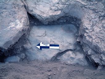
The soil deposits above the mosaic floor contained large quantities of tesserae, providing further support for the existence of a second story floor. A number of mortar patches and repairs, the latter accomplished with large white tesserae, were made to the mosaic along its western edge. It was not possible to excavate the northwest corner of the room, due to the presence of an obstructing modern retaining wall. In the southeastern corner of the room a small plaster niche (see image right) was uncovered directly on top of the mosaic floor, possibly the indication of a later reuse of this building. The upper portions of the niche had been destroyed in antiquity. However, traces of a yellow painted design were preserved on the inner portion of the niche.
CERAMICS AND SMALL FINDS
The pottery found in the rubble sealing the Field C complex consisted predominantly of 6th-7th and 8th -9th (?) Century C.E. material, including a number of glazed wares. In addition, excavations in the unpaved room along the back wall (visible in Square 5L22Y2; see plan above) produced a well-preserved surface strewn with smashed pots (including bowls, cooking pots and storage vessels; see Fig. 6 and Fig. 7), and a number of bronze (one an intact jug - see image left) and iron implements. The soil that filled this room also contained numerous fragments of painted plaster, including discernable portions of a Late Greek inscription and parts of two crosses. The small finds recovered thus far from the other rooms in the complex include numerous coins and a ceramic stamp seal incised with a cross.
When combined with the presence of 6th Century mosaics (dated on stylistic grounds), our excavations suggest that the complex experienced two distinct architectural phases, which straddled the Late Byzantine-Early Islamic transition. The first phase was constructed in the 6th Century (or Late Byzantine period), and included the mosaic pavements described above. The building was then renovated in the 7th or early 8th Century (i.e. the Umayyad period), when a vault was built over the mosaic floor in the southern room along the back wall, and supplementary walls were judiciously inserted to shore up several sagging walls elsewhere in the complex. The entire complex apparently was abandoned sometime later in the 8th Century. Although its primary function remains unclear, the building’s layout and associated finds suggest a wealthy private residence.
HISTORICAL CONTEXT
Christianity gained an early foothold in the Mādabā region, and by the mid-5th Century C.E., the Christian community had grown large enough to warrant the services of a bishop, a development recorded in the Acts of the Council of Chalcedon (451 C.E.). Although the town goes unmentioned in the literary sources for the remainder of the period, as the seat of a diocese, the town clearly continued to prosper, and over the succeeding two centuries (ca. 6-7th Centuries C.E.) witnessed the construction of numerous churches and other public structures. It was during this period that the many mosaic pavements for which Madaba is renown were laid, including the famous Map of Palestine.
Following the Islamic conquest and the establishment of the Umayyad Caliphate in the mid-7th Century, Mādabā continued to flourish. Renovations were carried out on a number of Byzantine churches, and the town remained the seat of a bishopric. Dedicatory inscriptions found in the Churchof St. Stephenat Umm al-Rasas, which dates to the Early Abbasid period, mention the names of two bishops from the diocese of Mādabā. Interestingly, however, in an episode which also dates to this period involving the pursuit of rebellious Umayyad partisans through the region, the town of Mādabāfails to receive any mention, despite specific references to the nearby towns of Hesban, Masuh, Ziza and Amman. References to Mādabā, both textual and epigraphic, cease entirely by the end of the 8th Century, and the town is not referred to again until the early nineteenth century, when western explorers began traveling through the region.
FIELD C CONSOLIDATION AND RESTORATION
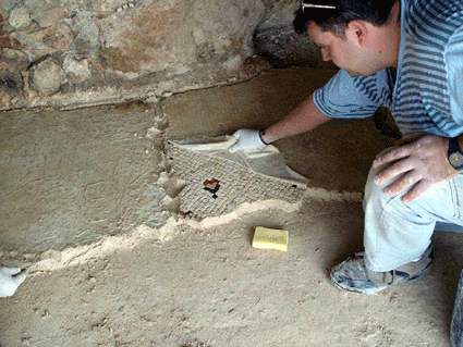
The ongoing effort to preserve the architecture in Field C continued during the 2002 field season. The edges of all of the partially preserved mosaic floors uncovered during previous field season were repaired and consolidated. In addition, the newly-uncovered second floor mosaic was also repaired. The walls enclosing the room containing the polychrome mosaic, which are faced with rapidly decaying plaster, were also consolidated, both the stone walls and the plaster facing. The walls and arches of the northeastern room of the complex will also need to be consolidated. Towards this end, an effort is being made to add mortar and plaster to this architecture and thus ensure its structural integrity, in advance of more permanent conservation.
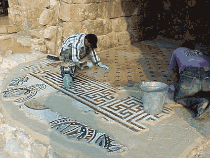
In summary, the 2002 conservation effort resulted in the stabilization and consolidation of most of the architectural remains visible in Field C, and they are now ready to be restored and presented to the public. In anticipation of this next phase of fieldwork, a program to restore the mosaic pavements lifted from the Field C complex in 1980 was initiated during the 2001 field season. Arrangements were made for the Italian restorer Franco Sciorilli to commence preparation of the mosaic pavement removed from the vaulted structure in the southeastern corner of the complex, and stored in the MadabaMuseum. This work was initiated in August, 2001, was resumed during the 2002 field season, and will continue into the fall. The mosaic currently is adhered to slabs of concrete bedding, which are being removed in preparation for the return of the pavement to its place on the site.
This phase of the project was completed off-site under Mr. Sciorilli's direction in a workshop at Khirbet al-Mukhayyat. In the fall of 2002, once the concrete backing had been removed, the individual sections of the mosaic were reinstalled within the vaulted room in the Field C complex.
ACKNOWLEDGEMENTS:
Funding for the 2002 field season was provided by a research grant from the Social Science and Humanities Research Council of Canada. The excavations were conducted in collaboration with the Department of Antiquities of Jordan, which provided guidance and access to field equipment. The season’s results would not have been possible without the dedicated help of Dr. Fawwaz al-Khraysheh, Director General of the Department of Antiquities, and Mr. Ali al-Khayyat, Director of the Department of Antiquities Office in Madaba.
** In addition to the Project Director and Assistant Director, the staff consisted of Celeste Barlow, Annlee Dolan, Jonathan Ferguson, Andrew Graham, Timothy Griffith, Fiona Haughey, Stanley Klassen, and Jode McKay. The student participants were Jason Barlow, David Bilton, Katherine Bourdeau, Chris Brown, Alice Butler, Stephanie Crocker, Sarah DeDecker, Elianna Fetterolf, Danielle Fraser, Patricia Grenon, Karen Harrington, Abram Harrison, Jennifer Jackson, Anthony Joaquim, Kathleen Jones, Michelle Larocque, Margaret Maitland, Alexis McBride, Christa Morgan, James Osborne, Jeffrey Quinlan, Sonia Radil, Lynda Service, Stacey Spadafore, Joseph Sproule, Alexander Subtelny, Lynn Welton, and Andrea Zanghellini-Silva.
 In keeping with the Tall Mādabā Archaeological Project (TMAP) objective to map architecture and assemble quantifiable artifact assemblages for each of the principal phases of occupation at the site, the 2002 field season saw a continuation of the excavations begun in 1998 along the west acropolis (Fields B and C; see Figure 2). The primary objectives of the 2002 TMAP field season, therefore, were
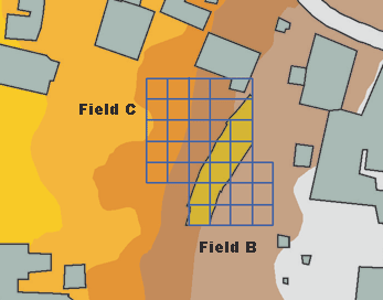 Excavations have been ongoing in Field B since 1998 (image left), and in that time deposits dating to the Late Ottoman (FP 1), Early Roman/Nabataean (FPs 2 and 3), Late Hellenistic (FPs 4 and 5), and Iron II (FP 6) periods have been exposed (see Figure 3). As stated above, the primary goal of the 2002 season in Field B was to continue excavation of the Iron Age remains first encountered during the 1998 season. To this end, two units (Squares 5M21V3 and 5M21U4) on the northern edge of the previously excavated area, and to the east of the large fortification wall, were reopened.
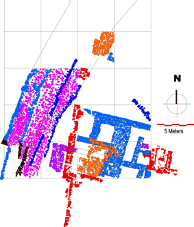 Square 5M21V3, in the northeastern corner of the excavation area, contained a room with a large pit of stones in the center. During the removal of this pit, a significant amount of Late Hellenistic material was recovered, indicating that it may have been the result of later activity that penetrated down into this Iron Age structure. Once the pit was removed, two surfaces with flat lying
 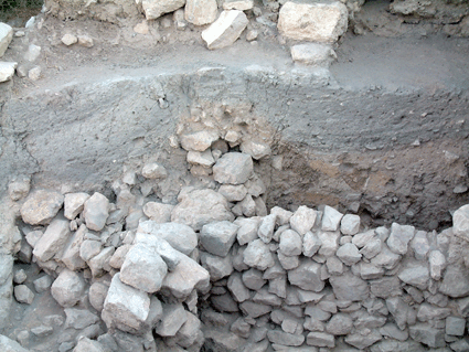 The removal of these deposits exposed more of the inner face of the monumental city wall to the west. Under these ash layers were the remains of a north-south wall with a possible
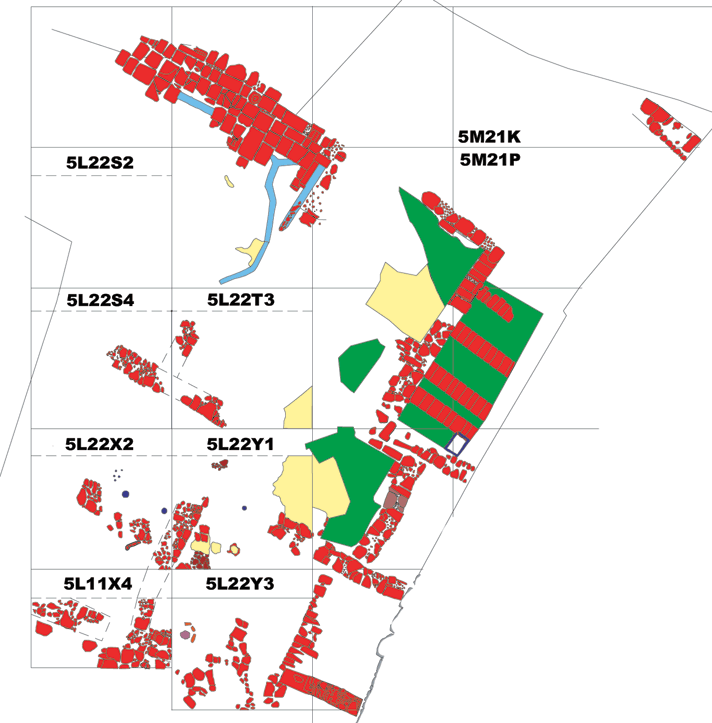
 The bedrock in this area was also carved with a number of post-holes, probably the sockets for doorways. Excavations in this lower area also uncovered more of the
 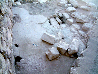 It sealed against the pre-classical fortification wall along its eastern edge, and was bordered by intact, free-standing walls on its northern and western sides. The southern wall of the room had been destroyed (probably eroded) in antiquity. The pavement sits on a series of large roofing slabs that are supported by three arches located in the
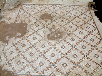 Excavations were also undertaken to the west of this room, and succeeded in uncovering a second well-preserved room. The floor of the room was paved with a polychrome mosaic (see image left), entirely intact except for two minor damaged portions in the center, and in the southwestern corner of the room, which had been destroyed by the bulldozer activity in 1980. The decoration consists of a simple grid of fleurettes with diamonds, executed in black, red, yellow, and white, with a black, red and yellow border. Two rows of triangular fleurettes flank the eastern edge of the mosaic, with a single row forming a border along the northern and southern sides. Traces of four
 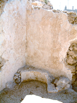 with matching springers outlined by a border comprised of two rows of tesserae along the southern wall, indicating that there had been two large arches supporting a ceiling, and possibly a second story floor.
 The pottery found in the rubble sealing the Field C complex consisted predominantly of 6th-7th and 8th -9th (?) Century C.E. material, including a number of glazed wares. In addition, excavations in the unpaved room along the back wall (visible in Square 5L22Y2; see plan above) produced a well-preserved surface strewn with smashed pots (including bowls, cooking pots and storage vessels; see
 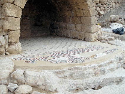 The ongoing effort to preserve the architecture in Field C continued during the 2002 field season. The edges of all of the partially preserved mosaic floors uncovered during previous field season were repaired and consolidated. In addition, the newly-uncovered second floor mosaic was also repaired. The walls enclosing the room containing the polychrome mosaic, which are faced with rapidly decaying plaster, were also consolidated, both the stone walls and the plaster facing. The walls and arches of the northeastern room of the complex will also need to be consolidated. Towards this end, an effort is being made to add mortar and plaster to this architecture and thus ensure its structural integrity, in advance of more permanent conservation.
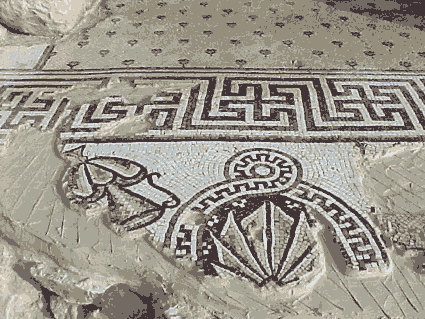 In summary, the 2002 conservation effort resulted in the stabilization and consolidation of most of the architectural remains visible in Field C, and they are now ready to be restored and presented to the public. In anticipation of this next phase of fieldwork, a program to restore the mosaic pavements lifted from the Field C complex in 1980 was initiated during the 2001 field season. Arrangements were made for the Italian restorer Franco Sciorilli to commence preparation of the mosaic pavement removed from the vaulted structure in
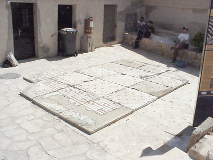 the southeastern corner of the complex, and stored in the MadabaMuseum. This work was initiated in August, 2001, was resumed during the 2002 field season, and will continue into the fall. The mosaic currently is adhered to slabs of concrete bedding, which are being removed in preparation for the return of the pavement to its place on the site.