|
The 2007 field season of the Tall Mādabā Archaeological Project concentrated solely on excavations in Field B. The primary objectives of this season were to reopen two units in order to complete the exposure of the Iron Age levels first encountered in 1998, explore more of the Early Roman/Nabatean and Hellenistic structures in a new unit adjacent to the main excavation area, and open two new units on the eastern edge of the site to expose remains closest to the centre of the tall. Excavation efforts have succeeded in clarifying the nature of the Iron Age settlement at Mādabā. Three occupation phases were studied this season, the earliest of which dates to the Late Bronze or Early Iron I periods based on the ceramic assemblage. Iron Age levels were also reached in the two easternmost units that were newly opened in 2007. Excavations in three new units during the 2007 season exposed more of the Early Roman/Nabatean structures previously excavated and confirmed the extensive nature of the later disturbance. A polychrome pavement, decorated with a grid and lozenge pattern, was also exposed in Field B. The fragment that remains, although heavily damaged, seals against a stone-built threshold equipped with a large door-post hole. An unexpected result of the 2007 season was the exposure of several more rooms of the Late Ottoman house that occupies the north-eastern corner of the excavation area, providing additional information about the beginning of the modern settlement at Mādabā.
In keeping with the Tall Mādabā Archaeological Project (TMAP) objective to map architecture and assemble quantifiable artifact assemblages for each of the principal phases of occupation at the site, the 2007 field season saw a continuation of the excavations begun in 1998 along the west acropolis (Field B; see Figure 2) (Harrison et al. 2003; Foran et al. 2004). The primary objectives of the 2007 TMAP field season, therefore, were
- to reopen two units in order to complete the exposure of the Iron Age levels first encountered in 1998
- to explore more of the Early Roman/Nabatean and Hellenistic structures in a new unit adjacent to the main excavation area
- to open two new units on the eastern edge of the site to expose remains closest to the centre of the tall.
In addition to excavation, time and resources were also devoted to improving the overall appearance of the site and assuring the protection of these remains after the field season. The 2007 season was conducted between June 11 and July 19, with the author acting as Project Director. An archaeological field school for students from the University of Toronto was also run in conjunction with the 2007 field season.* Isa Suriani served as the Department of Antiquities representatives.
Excavations have been ongoing in Field B since 1998, and in that time deposits dating to the Late Ottoman (FP 1), Late Byzantine (FP 2), Early Roman/Nabataean (FPs 3 and 4), Late Hellenistic (FPs 5 and 6), Iron IIC (FP 7), and Iron IIB (FP 8), Iron I/Iron IIA (FP 9), Late Bronze/ Iron IA (FP 10) periods have been exposed. As stated above, the primary goals of the 2007 season were to complete excavation of the Iron Age remains, expose more of the Early Roman/Nabatean and Hellenistic structures, and explore the innermost area of the tall. To this end, two units (Squares 5M21V3 and 5M21U4) on the northern edge of the previously excavated area, and to the east of the large fortification wall, were reopened and three new units (Squares 5M11B4, 5M21W1, and 5M21W3) were opened.
As already discussed in our previous reports, FP8 is represented by a large pillared building that is oriented N-S about 1.5 meters in from the fortification wall. This building had two exterior walls represented by 5M21U4:112 and 5M21V3:118. A series of pillars (5M21V3:147,148 and 149) were clearly constructed equidistant to the exterior walls to provide support for either the roof or 2nd story of the building. Surfaces associated with this building are most clear in the sequence recovered from 5M21U4 and are evident in the southern baulk as L.164 at the 786.33m ASL level. This surface (L.164) represents the 1st occupational surface of the Iron IIB settlement corresponding to FP8.2. The end of the Iron IIB phase of occupation at Tall Mādabā has been described as the result of a “destruction” (the nature of which is yet undetermined); however, the complete excavation of the FP8 structures has yielded a surprisingly small amount of cultural material. Ceramic counts are conspicuously low and posit either abandonment or an aggressive reconstruction/reuse campaign by the FP7 “squatters”.
FP 9 is represented by a monumental Iron I/IIA structure, partially excavated in 2006, which lies underneath the Iron IIB pillared building. Only the south-western corner of the building could be excavated, but two substantial double-row walls were exposed. The north-south wall (5M21U4:159) is abutted by another wall running east-west (5M21U4:158; 5M21V3:163), similar in material, style, and elevation. The north-south wall forms the exterior, western wall of the building, while the east-west wall appears to have been the southern, exterior wall; though, without excavating within the southern balk, this conclusion can only be postulated.
A distinct occupation layer (5M21U4:186, 187) was exposed north of the east-west wall of this building (5M21U4:158) during the 2006 season. A concentration of large, mendable pithoi sherds, dated to the Iron I period, was found associated with this surface. The remainder of these pithoi was removed in the 2007 season from the balk that divided this large room in two. The removal of this balk allowed the delineation of this surface to the east (5M21V3:178). A beaten earth surface (5M21U4:153, 199) was also excavated south of this structure during the 2007 season and flat-lying pottery was found resting on it. This surface (5M21U4:199) and that associated with the pithoi (5M21U4:186, 187) appear to be contemporary.
During the 2007 season, it became clear that the Iron I/Iron IIA architecture is dominated by a large room, which runs through both 5M21U4 and 5M21V3. The doorway to this space may lie in the eastern balk of 5M21V3, evidenced by a distinct break in the architecture (5M21V3:189), though no threshold has been found.
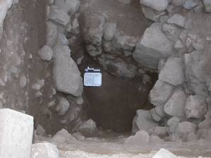
 FP 10 marks the earliest phase of occupation on the tall, dating to the Late Bronze/Iron I period. The associated architecture appears to have been built in two distinct phases. Initially, the massive fortification wall that dominates the site was constructed (FP 10.2) directly on the bedrock. The area was then leveled off with a fill layer (5M21U4:150,201,203,210,215,217,218; 5M21V3:187,192,193) covered with a plaster surface (5M21U4:149,214; 5M21V3:186,195), both of which seal against the fortification wall (see image left). FP 10 marks the earliest phase of occupation on the tall, dating to the Late Bronze/Iron I period. The associated architecture appears to have been built in two distinct phases. Initially, the massive fortification wall that dominates the site was constructed (FP 10.2) directly on the bedrock. The area was then leveled off with a fill layer (5M21U4:150,201,203,210,215,217,218; 5M21V3:187,192,193) covered with a plaster surface (5M21U4:149,214; 5M21V3:186,195), both of which seal against the fortification wall (see image left).
Shortly after the construction of the fortification wall and associated leveling operation, a single-course boulder and chink wall was built (FP 10.1). This wall runs roughly east-west from the fortification wall diagonally into the southern balk, and is parallel to the Iron I/Iron IIA architecture of FP 9. The wall was excavated as two loci: L.156 (the western half of the wall, extending from the fortification wall) and L.193 (the eastern half of the wall, extending into the southern balk). Although originally thought to extend down to bedrock, excavations during the 2007 season revealed that this wall was built on several fill layers (5M21U4:209,211,212,213). Directly below the FP9 surface (5M21U4:199) south of the wall (5M21U4:156, 193) was a layer of construction fill (5M21U4:200, 201), and below it a layer of cobbles (5M21U4:202). Beneath these fill layers is a cobble platform (5M21U4:207) which ties into the lower courses of the Iron I/Iron IIA wall (5M21U4:156, 193).
The first stage of excavations in 5M21W1 was successful in exposing a room associated with the Late Ottoman house (FP 1) to the north of the square. Two walls (5M21W1:3,5) delineated a space that was paved with a plaster floor (5M21W1:9). The soil loci inside this room (5M21W1:4,6,7,8) was full of modern debris. The layers below this floor contained signs of the disturbance caused by construction in the late 19th and early 20th centuries. This may help to explain the lack of any substantial architecture dating to the Early Roman/Nabatean (FP 3 and 4) and Late Hellenistic (FP 5 and 6) periods in this excavation unit.
 The remnants of a north-south wall (5M21W1:21) cut through the centre of the square. It may have been associated with a second wall (5M21W1:26) that runs east-west in the southern portion of the unit. The cultural material associated with this architecture suggests that it dates to the Early Roman/Nabatean occupation of the site. To the east of the north-south wall, a plaster-lined channel (5M21W1:38) was exposed. Although not directly connected, it appears that this feature is related to walls 21 and 26. The remnants of a north-south wall (5M21W1:21) cut through the centre of the square. It may have been associated with a second wall (5M21W1:26) that runs east-west in the southern portion of the unit. The cultural material associated with this architecture suggests that it dates to the Early Roman/Nabatean occupation of the site. To the east of the north-south wall, a plaster-lined channel (5M21W1:38) was exposed. Although not directly connected, it appears that this feature is related to walls 21 and 26.
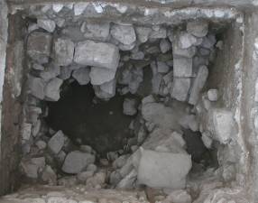
The lowest levels (5M21W1:35,36) excavated in 5M21W1 yielded strictly Iron II pottery, indicating that the occupation of the site in the Iron Age extended well-into the tall (see figure 8 - above). Safety concerns made it impossible to expose more of the Iron II layers in this square. Future excavation seasons will hopefully reveal more of this occupation layer.
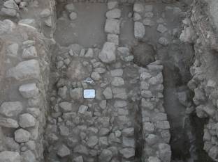
As in 5M21W1, excavations in 5M21W3 allowed the exposure of architecture associated with the Late Ottoman (FP 1) house to the north (Figure 7). An east-west wall located in the northern balk and a north-south wall in the western balk form another room of this building. A doorway in the wall in the northern balk connected this room with that in 5M21W1. A second east-west wall (5M21W3:3) ran through the centre of the square and was equipped with a doorway. The plaster floor (5M21W3:23) associated with this structure was also exposed.
Excavation continued under this architecture and succeeded in exposing a large, east-west running wall (5M21W3:29). The material culture recovered from this area clearly indicates that this wall is associated with the Early Roman/Nabatean (FP3 and 4) occupation levels at Tall Mādabā. Two Rhodian stamped amphora handles and a collection of 39 clay loom weights were all found in close proximity to this architecture. Unfortunately, the intrusion of late 19th/early 20th century buildings managed to destroy any other architecture associated with this wall.
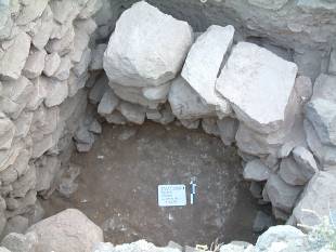
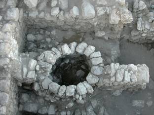
 A small sondage conducted in the north-west corner of the square at the end of the field season unexpectedly produce remains dating to the Iron II period (see figure 10 - left). A small portion of a pillared wall (5M21W3:36) that runs north-south was exposed. The soil layers associated with this architecture (5M21W3:34,35) yielded exclusively Iron II material. Safety concerns and time constraints made it impossible to expose more of the Iron II occupation in this square. Future excavation seasons will hopefully reveal more of this occupation layer. A small sondage conducted in the north-west corner of the square at the end of the field season unexpectedly produce remains dating to the Iron II period (see figure 10 - left). A small portion of a pillared wall (5M21W3:36) that runs north-south was exposed. The soil layers associated with this architecture (5M21W3:34,35) yielded exclusively Iron II material. Safety concerns and time constraints made it impossible to expose more of the Iron II occupation in this square. Future excavation seasons will hopefully reveal more of this occupation layer.
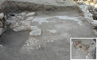 The heavy rainfall during the winter months exposed the fragile remnants of an in situ mosaic floor in the eastern baulk of the principal excavation area. The polychrome pavement (5M11B2:2), decorated with a grid and lozenge pattern, is extensively damaged (see Figure 11 - left). The fragment that remains, however, seals against a stone-built threshold (5M11B2:3) equipped with a large door-post hole (5M11B2:6). This threshold is built against the southern face of an east-west running wall (5M11B2:8). The heavy rainfall during the winter months exposed the fragile remnants of an in situ mosaic floor in the eastern baulk of the principal excavation area. The polychrome pavement (5M11B2:2), decorated with a grid and lozenge pattern, is extensively damaged (see Figure 11 - left). The fragment that remains, however, seals against a stone-built threshold (5M11B2:3) equipped with a large door-post hole (5M11B2:6). This threshold is built against the southern face of an east-west running wall (5M11B2:8).
 The Early Roman/Nabatean occupation of Mādabā is represented by two separate field phases (FP 3 and 4). Excavations in 5M11B4 succeeded in exposing more of the settlement dating to this period. This area is dominated by a large, circular pit (5M11B4:7) that was reused in the Late Ottoman period (FP 1). This feature, originally Early Roman/Nabatean in date, is tied into and supported by two walls (5M11B4:28,29) that run east-west through the centre of the unit. Two well-preserved walls (5M11B4:17,27) delineate the room in which the pit was located (see figure 12 - above). Unfortunately, due to the disturbance caused by the modern occupation of the site, no floor levels were found associated with this architecture. The Early Roman/Nabatean occupation of Mādabā is represented by two separate field phases (FP 3 and 4). Excavations in 5M11B4 succeeded in exposing more of the settlement dating to this period. This area is dominated by a large, circular pit (5M11B4:7) that was reused in the Late Ottoman period (FP 1). This feature, originally Early Roman/Nabatean in date, is tied into and supported by two walls (5M11B4:28,29) that run east-west through the centre of the unit. Two well-preserved walls (5M11B4:17,27) delineate the room in which the pit was located (see figure 12 - above). Unfortunately, due to the disturbance caused by the modern occupation of the site, no floor levels were found associated with this architecture.
 The removal of the Early Roman/Nabatean remains in 5M11B4 allowed the exposure of architecture dating to the Late Hellenistic period (FP 5 and 6). An east-west running wall (5M11B4:33) and a large cobbled surface (5M11B4:35) represent this phase of occupation. A circular, stone-built installation is located at the western edge of the cobbled area (see figure 13 - left). In addition, an area was excavated in the gap at the western end of the east-west wall. A small portion of a hard-packed plaster surface was exposed. Excavation of these features will have to take place in a future season. The removal of the Early Roman/Nabatean remains in 5M11B4 allowed the exposure of architecture dating to the Late Hellenistic period (FP 5 and 6). An east-west running wall (5M11B4:33) and a large cobbled surface (5M11B4:35) represent this phase of occupation. A circular, stone-built installation is located at the western edge of the cobbled area (see figure 13 - left). In addition, an area was excavated in the gap at the western end of the east-west wall. A small portion of a hard-packed plaster surface was exposed. Excavation of these features will have to take place in a future season.
The excavations in Field B during the 2007 season succeeded in providing more information on almost all of the field phases present in this area of the tall as well as revealing the existence of a field phase previously unidentified.
It is now clear that the Late Ottoman house (FP 1) on the northern edge of the site extended southward and was thus supplied with rooms on its exterior. The work conducted in 5M21W1 and 5M21W3 has allowed the identification of two occupation phases in this building. The plaster floor in 5M21W1 (Locus 9) is clearly later than that exposed in 5M21W3 (Locus 23). It is of a more substantial construction, resembling modern concrete, and was laid on a bed of cobbles. In contrast, the floor in 5M21W3 was made of a thin layer of plaster.
Although the importance of Mādabā during the Byzantine period is indisputable, until the 2007 season no architectural remains from this phase of occupation had been found in Field B. The architecture and associated installations in 5M11B2 clearly indicate the existence of a monumental structure on this part of the tall, unfortunately later occupation seems to have destroyed most of it. Future excavations to the east of this area will hopefully expose more of the structure.
Excavations in 5M11B4, 5M21W1, and 5M21W3 confirm that the Early Roman/Nabatean (FP 3 and 4) occupation at Tall Mādabā extended eastward; however, the remains along the eastern edge of the site are more heavily damaged than those to the west. When taken in conjunction with the architecture exposed during the 1998, 1999, and 2000 field seasons, the material excavated in 2007 betrays the presence of a substantial settlement at Mādabā during this period.
The Late Hellenistic occupation (FP 5 and 6) also appears to continue eastward, based on the work conducted in 5M11B4. Its absence in 5M21W1 and 5M21W3 may, in part, be due to later construction activity.
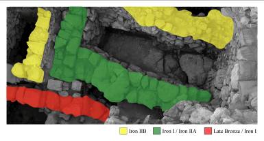 Based on the results of the 2007 excavations in 5M21U4 and 5M21V3, we are able to make some tentative conclusions as to the nature of the earliest occupation phases on the west acropolis of Tall Mādabā. The Iron Age settlement at Mādabā spans four distinct occupation phases (see figure 14 - left). The earliest coincides with the construction of the interior face of the fortification wall, sometime in the Late Bronze/Iron I period (FP 10), and the settlement activity that soon followed. The Iron I/Iron IIA period (FP 9) is represented by a monumental structure, of which only the south-western corner has been exposed. A pillared-building, dating to the Iron IIB (FP 8), was built above this earlier phase. The presence of the pillared wall in 5M21W3 suggests that this phase of occupation continued eastward. The final phase of Iron Age occupation, dating to the Iron IIC (FP 7), appears as what has been termed a “squatter” occupation, consisting of very poorly constructed buildings. Based on the results of the 2007 excavations in 5M21U4 and 5M21V3, we are able to make some tentative conclusions as to the nature of the earliest occupation phases on the west acropolis of Tall Mādabā. The Iron Age settlement at Mādabā spans four distinct occupation phases (see figure 14 - left). The earliest coincides with the construction of the interior face of the fortification wall, sometime in the Late Bronze/Iron I period (FP 10), and the settlement activity that soon followed. The Iron I/Iron IIA period (FP 9) is represented by a monumental structure, of which only the south-western corner has been exposed. A pillared-building, dating to the Iron IIB (FP 8), was built above this earlier phase. The presence of the pillared wall in 5M21W3 suggests that this phase of occupation continued eastward. The final phase of Iron Age occupation, dating to the Iron IIC (FP 7), appears as what has been termed a “squatter” occupation, consisting of very poorly constructed buildings.
The 2007 field season of the Tall Mādabā Archaeological Project were conducted in collaboration with the Department of Antiquities of Jordan, which provided guidance and access to field equipment. The season’s results would not have been possible without the dedicated help of Dr. Fawwaz al-Khraysheh, Director General of the Department of Antiquities, and Mr. Ali al-Khayyat, Director of the Department of Antiquities Office in Mādabā.
In addition to the Project Director, the staff consisted of Sarah Jagelewski, Jennifer Lewis, Amanda Parks, and John Sleath. Junior staff members included Zandra Mallinson, Paulo Raposo, Elsbeth Sufrin-Disler, and Bryan Wyshnicki. The student participants were Jeffrey Aviss, Robert Cumming, Michelle Davies, Marisa Franz, Leta Greer, Alison Haines, Hannah Jacobs, Maciej Janicki, Jad Kaado, Kevin Kwai, Hao Li, Erika Loney, Chelsea Mayne, Simon Pond, Isabel Ritchie, Kimberly Ross, Sean Ross, Aviv Toren, Hannah Turner, and Laura White.
|