|
Click below to see archival footage of excavations at Tell Madaba in 2009 (forthcoming).
 In keeping with the Tall Mādabā Archaeological Project (TMAP) objective to map
architecture and assemble quantifiable artifact assemblages for each of the principal phases of
occupation at the site, the 2009 field season saw a continuation of the excavations begun in
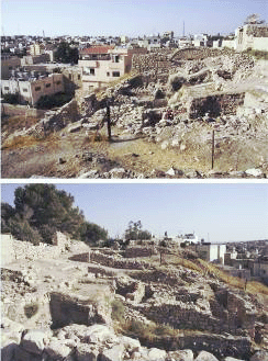
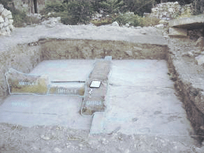
1998 along the west acropolis (Field B; see Figure 2) (Harrison et al. 2003; Foran et al.
2004). The primary objectives of the 2009 TMAP field season, therefore, were 1) to reopen
one unit in order to expose more of the Iron Age levels present on the site; 2) to explore more
of the Early Roman/Nabatean and Hellenistic structures in one new unit adjacent to the main
excavation area; and 3) to open one new adjacent to the area inside the Late Ottoman house
on the southern edge of the site excavated in 2008. In addition to excavation, time and
resources were also devoted to improving the overall appearance of the site and assuring the
protection of these remains after the field season. The 2009 field season also included one
full week of laboratory work, during which time all of the artefacts from the 2009 season
were catalogued and prepared for storage or shipment and pottery and objects from the 2008
and 2009 seasons were drawn. In keeping with the Tall Mādabā Archaeological Project (TMAP) objective to map
architecture and assemble quantifiable artifact assemblages for each of the principal phases of
occupation at the site, the 2009 field season saw a continuation of the excavations begun in
1998 along the west acropolis (Field B; see Figure 2) (Harrison et al. 2003; Foran et al.
2004). The primary objectives of the 2009 TMAP field season, therefore, were 1) to reopen
one unit in order to expose more of the Iron Age levels present on the site; 2) to explore more
of the Early Roman/Nabatean and Hellenistic structures in one new unit adjacent to the main
excavation area; and 3) to open one new adjacent to the area inside the Late Ottoman house
on the southern edge of the site excavated in 2008. In addition to excavation, time and
resources were also devoted to improving the overall appearance of the site and assuring the
protection of these remains after the field season. The 2009 field season also included one
full week of laboratory work, during which time all of the artefacts from the 2009 season
were catalogued and prepared for storage or shipment and pottery and objects from the 2008
and 2009 seasons were drawn.
The 2009 season was conducted between July 5 and August 6, with the author acting
as Project Director. An archaeological field school for students from the University of
Toronto was also run in conjunction with the 2009 field season. Kholood Agrabawi and
Ammel Khaled Rwahneh served as the Department of Antiquities representatives.
 To the west of 5M11B4:96, a very large limestone mortar (5M11B4:121 / 09.87) was
unearthed. Although there is no surface clearly associated with this installation, a
group of small cobbles formed a ring around the exterior of the mortar and a substantial
amount of ash was found in the soil (5M11B4: 131) surrounding it, indicating perhaps the
presence of a domestic cooking area. To the west of 5M11B4:96, a very large limestone mortar (5M11B4:121 / 09.87) was
unearthed. Although there is no surface clearly associated with this installation, a
group of small cobbles formed a ring around the exterior of the mortar and a substantial
amount of ash was found in the soil (5M11B4: 131) surrounding it, indicating perhaps the
presence of a domestic cooking area.
 After exposing the bottom course of 5M11B4:96, it was clear that this wall was
sitting on an earlier structure (5M11B4:139). The construction technique of this
earlier wall, consisting mostly of a single row of very large boulders, is similar to that of the
Iron I/Iron IIA (FP 9) architecture exposed in 5M21U4 and 5M21V3 (5M21U4:158, 159;
5M21V3:163). The top elevation of this wall (789.488m ASL) is significantly higher than
the associated structures previously excavated (786.48m ASL); however, this confirms earlier
assumptions that the bedrock in this area slopes upward from west to east, thus creating a
series of terraces upon which these structures were built. After exposing the bottom course of 5M11B4:96, it was clear that this wall was
sitting on an earlier structure (5M11B4:139). The construction technique of this
earlier wall, consisting mostly of a single row of very large boulders, is similar to that of the
Iron I/Iron IIA (FP 9) architecture exposed in 5M21U4 and 5M21V3 (5M21U4:158, 159;
5M21V3:163). The top elevation of this wall (789.488m ASL) is significantly higher than
the associated structures previously excavated (786.48m ASL); however, this confirms earlier
assumptions that the bedrock in this area slopes upward from west to east, thus creating a
series of terraces upon which these structures were built.
During the final week of excavation in 5M11B4, the Iron I/Iron IIA wall
(5M11B4:139) was completely exposed, revealing only two courses. It became clear that the
soil loci excavated to the east of this wall continued underneath it. It was therefore decided to
remove the wall in order to completely expose these strata. A thick layer of ash and burnt
material (5M11B4:133), initially exposed in the south-east corner of the square, continued
throughout the entire area, albeit tapering off to the west. The soil under this burnt layer
(5M11B4:136) contained a surprising number of artefacts. A total of 13 spindle whorl
fragments, a possible stone weight, and a stone pounder were recovered.
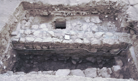
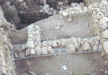
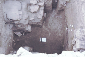 By the end of this season, very little architecture remained in 5M11B4 (Figure 7),
only the soil loci exposed by the removal of locus 136 are visible. Thus, this square is wellpoised
for future excavation. It is our intention to continue work in this unit and recover
more of the earlier Iron Age material from Tall Mādabā.
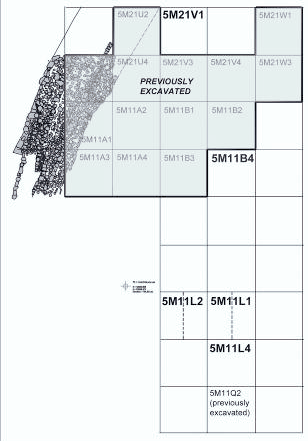
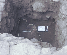
The square designated as 5M11L1 in actuality comprises the western half
of 5M11L1 and the eastern half of 5M11L2 (see above plan of Field B). This adjustment had to be made to
allow access to the site and not compromise any of the surrounding standing architecture.
Excavation in 5M11L1 began on July 20, half way through the 2009 field season. After the
discovery of a modern cistern in 5M11L4 (see below), it was decided to move northward in
order to expose the northern limit of this cistern and possibly recover more ancient material
that had not been destroyed by modern constructions.
Once the top soil and modern debris had been removed, a cement floor (5M11L1:3)
was exposed in the southern half of the square (above, right). This composition of this floor
indicates that it dates to an earlier period than those excavated in 5M11L4 (see below). A
cement pipe running northward under this floor led to a stone-built septic tank (5M11L1:15,
16, 17, 18 , 19) that comprised the northern half of the square and was certainly built within
the last 100 years (FP 1), although perhaps reusing some earlier architecture (above, left). Due
to the presence of this installation, excavation initially concentrated on the southern half of
the square.
 The removal of the cement floor (5M11L1:3) exposed a small north-south wall
(5M11L1:6) cut by the southern wall of the septic tank (5M11L1:18). Although
it is difficult to determine, this wall may be the continuation of the wall (5M11Q2:36)
exposed in the western baulk of 5M11Q2 during the 2008 field season. The soil loci sealing
against this wall (5M11L1:8, 9, 10, 11, 14) contained mostly Hellenistic ceramics, indicating
that it should be associated with the Late Hellenistic strata at the site (FP 5 & 6). In addition,
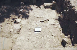
the remains of a plaster surface (5M11L1:12) were uncovered directly against this wall
(below). This type of flooring is typical of the Late Hellenistic remains at Tall Mādabā
(e.g. 5M11B4:49 and 5M21V4:33), thus further confirming the dating of this structure. The removal of the cement floor (5M11L1:3) exposed a small north-south wall
(5M11L1:6) cut by the southern wall of the septic tank (5M11L1:18). Although
it is difficult to determine, this wall may be the continuation of the wall (5M11Q2:36)
exposed in the western baulk of 5M11Q2 during the 2008 field season. The soil loci sealing
against this wall (5M11L1:8, 9, 10, 11, 14) contained mostly Hellenistic ceramics, indicating
that it should be associated with the Late Hellenistic strata at the site (FP 5 & 6). In addition,
the remains of a plaster surface (5M11L1:12) were uncovered directly against this wall
(below). This type of flooring is typical of the Late Hellenistic remains at Tall Mādabā
(e.g. 5M11B4:49 and 5M21V4:33), thus further confirming the dating of this structure.
Excavation continued in the south-west corner of the square under the Late
Hellenistic plaster surface (5M11L1:12). The soil loci removed (5M11L1:14, 21, 22, 23)
contained mostly Iron II material (FP 7 & 8). Thus, as elsewhere on site, Iron II remains are
located directly below the Late Hellenistic strata. No architecture was uncovered in this area,
but a significant amount of ceramic material was recovered.
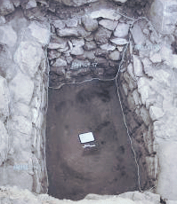
Excavation was undertaken in the northern half of the square once the roof of the
septic tank (5M11L1:15) had been removed. The debris accumulated in the septic tank lay at
approximately 1.5 m below the tops of the walls (see above). Once this modern accumulation
(5M11L1:20) had been removed, the ancient deposits could be excavated. A hard packed
gray layer (5M11L1:24) lay directly beneath locus 20. This may be the remains of the
sheetwash that seals in the Iron Age remains elsewhere on site (5M21V3:91), although the
modern structure built above it has rendered any definitive conclusions impossible.
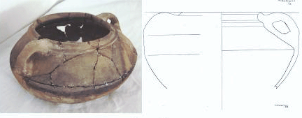
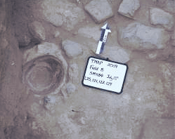
The layers of soil beneath the sheetwash (5M11L1:25, 26) contained
exclusively Iron II material. A nearly complete cooking pot (left) was
recovered as well as a nice example of an Iron Age spindle whorl. The
possible remains of an east-west running wall (5M11L1:27) were uncovered within these soil
loci (below). The exact nature of this structure could not be determined due to time
constraints and difficulty of access to the excavation area.
 Although the results produced from the work in 5M11L1 indicate the presence of
important remains from the Late Hellenistic period and the Iron Age in this area of the site,
the depth of these remains and the modern structures built above them make further
excavations in this location impossible. However, our efforts during the 2009 season have at
least confirmed that the settlements dated to these periods extended to this area of the site.
Although the results produced from the work in 5M11L1 indicate the presence of
important remains from the Late Hellenistic period and the Iron Age in this area of the site,
the depth of these remains and the modern structures built above them make further
excavations in this location impossible. However, our efforts during the 2009 season have at
least confirmed that the settlements dated to these periods extended to this area of the site.
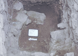
 Excavations were started in 5M11L4 at the beginning of the 2009 field
season. After having cleared the top soil and modern debris, the remnants of a modern
dwelling, possibly built within the last 50 or 60 years, were uncovered. A series
of cement floors (5M11L4:2, 3, 4), divided by a north-south wall (5M11L4:5, 9), an eastwest
wall (5M11L4:6), and a number of thresholds (5M11L4:7, 8, 10), were exposed. Excavations were started in 5M11L4 at the beginning of the 2009 field
season. After having cleared the top soil and modern debris, the remnants of a modern
dwelling, possibly built within the last 50 or 60 years, were uncovered. A series
of cement floors (5M11L4:2, 3, 4), divided by a north-south wall (5M11L4:5, 9), an eastwest
wall (5M11L4:6), and a number of thresholds (5M11L4:7, 8, 10), were exposed.
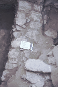
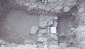
Once this modern dwelling had been removed, excavation continued in 5M11L4. A
stone wall (5M11L4:13) was exposed (below, left) directly beneath the later mud and plaster
construction (5M11L4:5, 9). As we later discovered, this wall acts as the eastern extent of a
modern cistern (5M11L4:18). The presence of this cistern made it impossible to continue
excavation in the western half of 5M11L4; thus, efforts were concentrated on the eastern half.
A large stone wall (5M11L4:20) was exposed along the square’s eastern baulk (below, right). The difference in the direction of this wall indicates that it is not part of the Late Ottoman structures. Given its size and construction style, it most likely dates to the Late Hellenistic period (FP 5 & 6); unfortunately, the disturbed state of the remains in this area prevent a more precise dating of this structure.
 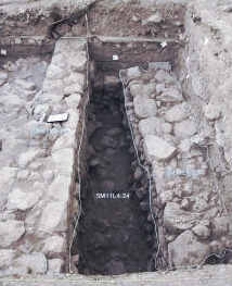
The area between walls 13 and 20 was excavated to a depth of approximately 1 m at
which point a substantial layer of rock tumble (5M11L4:24) was exposed and excavation was
halted (above, right). The material recovered from this area (5M11L4:21, 22) was completely
mixed, clearly the result of the construction of the adjacent cistern. These results were the
determining factor in the decision to discontinue excavation in this square.
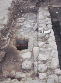 The presence of the modern cistern (5M11L4:18) in the western half of 5M11L4 was
first noted when one of its openings was discovered in the south-western corner of the square,
directly under the cement floor. The removal of soil over the roof of the cistern allowed the
exposure of a second opening to the cistern (left). The large stone blocking the
opening was taken out in order to allow further exploration of this feature. The cistern still
contained approximately 2 m of water; thus, the rest of the field season was spent removing
this water in order to determine the exact dimensions of the cistern and the construction
techniques used to build it. The presence of the modern cistern (5M11L4:18) in the western half of 5M11L4 was
first noted when one of its openings was discovered in the south-western corner of the square,
directly under the cement floor. The removal of soil over the roof of the cistern allowed the
exposure of a second opening to the cistern (left). The large stone blocking the
opening was taken out in order to allow further exploration of this feature. The cistern still
contained approximately 2 m of water; thus, the rest of the field season was spent removing
this water in order to determine the exact dimensions of the cistern and the construction
techniques used to build it.
During the final week of excavations, members of the team were finally able to enter
the cistern and record its different features. It has a vaulted ceiling built of small stones
similar to those used in other Late Ottoman (FP 1) constructions on site. There are also 3
openings in the ceiling that area visible from the interior of the cistern (Figure 19). Its walls
are straight and descend to a depth of approximately 5.07 m, at which point they taper in and
continue for another 1.56 m; thus, the cistern extends to a depth of approximately 6.63 m.
The corners of the cistern are rounded (Figure 20) as is the point where the walls meet the
floor. The cistern was obviously designed in this manner because it must be able to hold
water. The lower portion of the cistern measures approximately 2.41 m east-west and 3.74 m
north-south, while the upper portion measures 2.84 m east-west and 4.23 m north-south.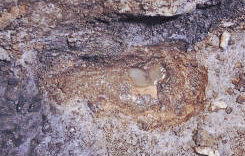 The
vaulted ceiling begins approximately 4.60 m from the floor. Taking into account all of these
measurements, we can ascertain that this cistern could contain over 60 cubic meters of water,
thus making it an important addition to the dwellings located on this area of the site.
The upper portions of the cistern were clearly built of stone and then covered with
plaster and cement; however, the exact nature of its lower segments remain ambiguous. They
may indeed simply have been dug directly out of the soil. In order to determine the nature of
the foundation of the cistern, a small area of the cement was chipped out (left).
It appears that the cistern is founded directly on bedrock, giving us an idea of the height of the
bedrock in this location. The
vaulted ceiling begins approximately 4.60 m from the floor. Taking into account all of these
measurements, we can ascertain that this cistern could contain over 60 cubic meters of water,
thus making it an important addition to the dwellings located on this area of the site.
The upper portions of the cistern were clearly built of stone and then covered with
plaster and cement; however, the exact nature of its lower segments remain ambiguous. They
may indeed simply have been dug directly out of the soil. In order to determine the nature of
the foundation of the cistern, a small area of the cement was chipped out (left).
It appears that the cistern is founded directly on bedrock, giving us an idea of the height of the
bedrock in this location.
 Excavations were newly undertaken in square 5M21V1 at the northern end
of the previously excavated area. Once the accumulation of debris from previous field
seasons was complete, formal excavations could begin. As the top soil and modern garbage
were removed, two walls (5M21V1:3, 4) were exposed (left)) that were clearly
associated with the adjacent Late Ottoman house (FP 1).
page 42 of 54
Once these later walls were removed, excavation of the soil beneath them was
undertaken. Although no associated architecture was recovered, these layers (5M21V1:9, 11,
12, 14, 15, 16, 18) produced mainly Early Roman/Nabatean (FP 3 & 4) artefacts indicating
the presence of a settlement dating to this period. As elsewhere on the site, the Early
Roman/Nabatean architecture was most likely removed during the construction of the Late
Ottoman structures.
The removal of these Early Roman/Nabatean layers exposed two Late Hellenistic
walls (5M21V1:19, 20) forming a corner and preserved to a height of 3 courses (Figure 23).
The presence of these walls had already been noted in the southern and western sections that
had been exposed by previous excavations in 5M21V3 and 5M21U2. A large amount of rock
tumble was recovered from the area adjacent to these walls, indicating that originally these
stone walls stood much higher. The soil loci sealing against these walls (5M21V1:21, 22, 23)
showed a predominance of Hellenistic material, confirming our assumption that this
architecture is associated with the second phase of Late Hellenistic occupation on the site (FP
5).
These Late Hellenistic walls (5M21V1:19, 20) form a rectangular room with the
walls previously exposed in the adjacent square (5M21U2:17, 20, 33) (below). Excavations were newly undertaken in square 5M21V1 at the northern end
of the previously excavated area. Once the accumulation of debris from previous field
seasons was complete, formal excavations could begin. As the top soil and modern garbage
were removed, two walls (5M21V1:3, 4) were exposed (left)) that were clearly
associated with the adjacent Late Ottoman house (FP 1).
page 42 of 54
Once these later walls were removed, excavation of the soil beneath them was
undertaken. Although no associated architecture was recovered, these layers (5M21V1:9, 11,
12, 14, 15, 16, 18) produced mainly Early Roman/Nabatean (FP 3 & 4) artefacts indicating
the presence of a settlement dating to this period. As elsewhere on the site, the Early
Roman/Nabatean architecture was most likely removed during the construction of the Late
Ottoman structures.
The removal of these Early Roman/Nabatean layers exposed two Late Hellenistic
walls (5M21V1:19, 20) forming a corner and preserved to a height of 3 courses (Figure 23).
The presence of these walls had already been noted in the southern and western sections that
had been exposed by previous excavations in 5M21V3 and 5M21U2. A large amount of rock
tumble was recovered from the area adjacent to these walls, indicating that originally these
stone walls stood much higher. The soil loci sealing against these walls (5M21V1:21, 22, 23)
showed a predominance of Hellenistic material, confirming our assumption that this
architecture is associated with the second phase of Late Hellenistic occupation on the site (FP
5).
These Late Hellenistic walls (5M21V1:19, 20) form a rectangular room with the
walls previously exposed in the adjacent square (5M21U2:17, 20, 33) (below).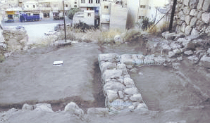 A
possible surface (5M21V1:27) was exposed inside this room. In addition to the ceramics and
artefacts recovered in association with this surface, the remains of a tabun (5M21V1:28) were
discovered against the southern face of wall 20 (Figure 24), suggesting that this area was
probably used for food production.
Excavations in 5M21V1 came to a conclusion with the exposure of the top of the
thick layer of sheetwash that seals in the Iron Age remains previously excavated in 5M21V3
(5M21V3:91). If further work is undertaken in 5M21V1, the remains dating to the Late
Hellenistic period will have to be removed in order to expose the entirety of this sheetwash
and thus allow the exploration of the Iron Age material that certainly lies under it. A
possible surface (5M21V1:27) was exposed inside this room. In addition to the ceramics and
artefacts recovered in association with this surface, the remains of a tabun (5M21V1:28) were
discovered against the southern face of wall 20 (Figure 24), suggesting that this area was
probably used for food production.
Excavations in 5M21V1 came to a conclusion with the exposure of the top of the
thick layer of sheetwash that seals in the Iron Age remains previously excavated in 5M21V3
(5M21V3:91). If further work is undertaken in 5M21V1, the remains dating to the Late
Hellenistic period will have to be removed in order to expose the entirety of this sheetwash
and thus allow the exploration of the Iron Age material that certainly lies under it.
The excavations in Field B during the 2009 season succeeded in providing more
information on almost all of the field phases present in this area of the tall.
The history of the reoccupation of Mādabā during the Late Ottoman period is well
known. The Field B excavations have exposed numerous walls associated with the visible
architecture on the site, in addition to several installations that were surely associated with
these 19th century structures (FP 1). Two walls associated with the Late Ottoman house on
the northern edge of the site, a stone-built septic tank, and a large cistern can now be added to
this field phase.
To date the remains of a large structure dating to the Late Hellenistic period (FP 5 &
6) have been unearthed in Field B at Tell Mādabā. During the 2009 season, more of this
building and other contemporary structures were uncovered. This new information allows us
to add to the plan of the 3rd – 2nd century structure that was built just inside the pre-classical
fortification wall on the western side of the acropolis. Other remains dating to the same
phases were excavated on the southern edge of the site; however, the construction of 19th
century and modern structures has destroyed most of the vestiges of the Late Hellenistic
occupation in this location.
During the 2007 season, the earliest occupation phase on the west acropolis was
exposed along the inner face of the city’s fortification wall. This provided a clear occupation
sequence that began in the Late Bronze/Early Iron I (FP 10) and continued until the late Iron
IIB (FP 7). The 2008 excavations successfully revealed that the thick layer of sheet-wash
that seals in the Iron Age remains is not present everywhere on the tell. This fact was further
confirmed by the work undertaken during the 2009 field season.
The latest Iron Age phase at Tell Mādabā (FP 7) dating to the late Iron IIB period
consists of what has been termed a ‘squatter’ occupation. The earlier Iron IIB phase (FP 8),
page 44 of 54
is represented by a pillared building exposed in the previously excavated area. Architecture
uncovered in 2008, previously thought to belong to the later ‘squatter’ phase, should instead
be associated with the earlier Iron IIB occupation (FP 8). The construction style and
ceramics associated with this structure have enabled us to relate it to the pillared building. In
addition, the architecture and soil layers under this phase are clearly associated with the
earlier Iron I/Iron IIA occupation (FP 9). Iron II material was also recovered from the
southern edge of the site. Although no architecture was exposed, the ceramics and objects
recovered confirm the extent of the settlement dating to the Iron IIB at Tell Mādabā.
The 2009 field season of the Tall Mādabā Archaeological Project has provided further
proof of the city’s importance, not only in the Byzantine period, but throughout the Iron Age,
Late Hellenistic, and Early Roman/Nabataean periods. Our efforts are also continually
contributing to this history of the modern city of Mādabā. |