Click below to see archival footage of excavations at Tell Madaba in 1999 and 2000
Introduction:
The Tall Madaba Archaeological Project (TMAP), as part of a broader, regional research effort that seeks to test prevailing theories about the development of centralized institutions and the rise of early state-ordered societies in the southern Levant, was initiated for the specific purpose of gathering archaeological data from the presumed urban center of a regional settlement network for comparison with data sets from functionally differentiated sites in the region. Two preliminary field seasons were conducted in 1993 and 1996 in order to create an integrated base map (using GIS software technology) delineating the settlement parameters of the site, and to establish a stratigraphic profile of the lower mound of the tall (Field A) (for more detailed descriptions of the project research objectives and the results of these preliminary field seasons, see Harrison 1996b; 1997; Harrison et al. 2000). The present phase of the TMAP investigations was launched in 1998, and marked the shift to full-scale excavations along the western slope of the upper mound (or 'acropolis') of the tall (Figs. 1 and 2).1 The primary aim of these excavations has been to develop a detailed record of the principal cultural strata preserved at Tall Madaba. More specifically, these investigations seek to:
Assemble extensive, quantifiable collections of botanical, faunal, ceramic, and lithic materials for each of the principal phases of occupation at the site.
Map and record associated architectural remains.
Conduct the preliminary processing and laboratory analysis of the material evidence recovered.
Integrate the architectural and artifact records in a relational database that will permit the detailed regional comparative analyses necessary to address the broader research objectives of the project.
Since this data collection phase is still in progress, this report will present the preliminary results achieved during the 1998, 1999 and 2000 field seasons. At the start of the 1998 season, five squares were opened along the crest of the west slope of the upper mound, immediately to the east of a large fortification wall that protruded above the tall surface. This area was designated Field B (Fig. 2). The Field B excavations were expanded during the 1999 and 2000 seasons, and by the end of the 2000 season had succeeded in uncovering a stratified sequence spanning four distinct cultural strata dating to the Late Ottoman (late 19th to early 20th Centuries), Early Roman/Nabataean (1st Century B.C.E. to early 2nd Century C.E.), Late Hellenistic (2nd to 1st Centuries B.C.E.), and Iron II (9th-7th Centuries B.C.E.) periods. Excavations were also initiated immediately to the west of Field B, along the exterior face of the fortification wall. Due to the stratigraphic break created by the wall, and to provide greater flexibility in excavation strategy, this western area was assigned a separate field designation, Field C (Fig. 2). Originally exposed by bulldozing activity in the early 1980s, the Field C excavations have revealed the well-preserved remains of a large residence occupied during the Late Byzantine and Early Islamic periods (ca. 6th-7th to mid 8th Centuries C.E.).
FIELD B EXCAVATIONS: Using the north-south east-west grid system established during the 1993 surface survey of Madaba, five 5 X 5 m excavation units (5M21U3, 5M21U4, 5M11A1, 5M11A2 and 5M11A3), or a total area of 125 sq m, were opened in 1998 (Fig. 3). Five additional squares were opened in 1999 (5M21U2, 5M21V3, 5M11B1, 5M11B3 and 5M11A4), extending Field B to the north and east, and expanding the field laterally by another 125 sq m, for a total excavated area of 250 sq m. The 1999 excavations were conducted primarily to gain greater horizontal exposure of each of the Field Phases (FP) uncovered in 1998 and thereby develop a more extensive record of each cultural horizon, before probing deeper into earlier strata. By the end of these two seasons, excavations had succeeded in uncovering substantial deposits and architectural remains from the Iron II, Late Hellenistic, Early Roman/Nabataean, and Late Ottoman periods, delineated in a six-phase stratified sequence. The 2000 excavations in Field B were confined to Squares 5M21U4, 5M21V3, 5M11A2, and 5M11B1, a 100 sq m area that incorporates the northern half of the Field (Fig. 3). In addition, a new square (5M21U1) was opened to further delineate the northern extent of the pre-classical fortification wall (see further description below).
Field Phase Six (Iron II):
ARCHITECTURE The large fortification wall separating Fields B and C represents the earliest structure uncovered thus far along the western slope of the upper mound (Fig. 3). Its external face had been exposed previous to our excavations, and in its original phase was constructed directly on bedrock. The wall is best preserved in Squares 5M21U1-3, where it stands to a height in excess of 5 m along its external face. Our excavations suggest a complex construction history that included at least two apparent efforts to expand the width of the wall. The latter of these two events brought the wall to 5 m in width. The limited vertical exposure achieved thus far along the inner face of the wall prevents a more precise dating of its construction history. Nevertheless, based on the soil deposits (see further description below) that seal against this latter expansion, it is clear that this effort to widen the wall occurred during the Iron II period, or earlier. This expansion of the fortification wall in turn rested directly on top of an earlier expansion that extended the composite width of the wall to as much as 7 m in some areas. The date of this earlier rebuild is still not known. The construction sequence, best evidenced in Square 5M21U3 (Fig. 3), thus points to the initial creation of a free-standing wall that averaged 2-3 m in width, with an inner and outer face constructed of large unhewn boulders. The date for the construction of this original wall remains unknown. At a later date (also unknown at this stage of our excavations) this wall was expanded to at least 7 m in width. The original fortification wall then received a second rebuild, probably during the Iron II period, which was placed directly on top of the earlier renovation, reducing the width of the structure to 5 m. Both expansions were accomplished by constructing a new inner face to the wall using large unhewn boulders, with the space between the new inner wall line and the original wall face filled loosely with small boulder-sized rock. By the end of the 2000 season, excavations in Field C along the outer face of the wall, combined with efforts to clear the large amounts of rubble left by earlier bulldozing activity (see further below), had brought the exposed length of this monumental structure, clearly the western fortification line of the Iron II (and possibly earlier) town, to approximately 25 m. During the 1999 season, a small probe was excavated in 5M11A1 against the face of the earlier expansion wall. By the end of the season, the probe had reached approximately two meters in depth, and had exposed more than six courses of the wall face. The probe also uncovered the corner of a structure constructed of unhewn stone, extending from the east balk of the square (Fig. 3). In addition to the excavations in 5M11A1, limited probes in 5M21U2 and 5M21U4 also reached Iron IIB levels during the 1999 season. To date, the earliest depositional remains uncovered in Field B consist of a thick deposit of thinly laminated layers of gray, ashy sheet wash, preserved primarily in Square 5M21U4. Micromorphological analyses (both bulk sediment and thin section analysis) conducted on samples from these layers suggest that they represent post-abandonment debris accumulation, most likely created by the progressive erosion of abandoned structures during the annual rains.2 Along the western edge of Square 5M21U4, the sheet wash was sealed by a layer of mud brick detritus, which in turn also sealed against the inner face of the expanded fortification wall. The upper course of a single wall segment was also uncovered to the east, in Square 5M21V3 (Fig. 3). Until excavations have reached greater depth, and have clarified the stratigraphic relationships between these disparate remains, they have been assigned provisionally to FP 6.
CERAMICS
Since excavation of the Iron II strata in Field B had not yet reached occupational levels by the end of the 2000 field season, observations about the Iron Age ceramic industry must remain preliminary and tentative for the time being. Nevertheless, the post-abandonment deposits uncovered in Field B have produced a large volume of Iron II pottery, and it was decided that this material might be used to begin the process of classifying and characterizing the ceramic industry. To initiate this process, a corpus of pottery was drawn from a sequence of seven stratigraphically superimposed soil layers (or loci) in Square 5M11A1, which has produced the best preserved Iron Age sequence excavated thus far in Field B. The assemblage was collected systematically by means of a comprehensive screening regime, resulting in a total sherd count of 4,003 from the seven loci, with diagnostic rim sherds accounting for 311 of the total, or just under 10% of the assemblage. To establish a preliminary typology, the assemblage was sorted according to functional type (e.g. bowls, kraters, cooking pots, store jars, jugs, juglets and lamps), with metric attributes such as rim diameter providing secondary criteria. Macroscopic fabric data was also gathered from each vessel sherd to further aid in the characterization of this material. As illustrated in Figures 4 and 5, the analyzed assemblage from Field B produced a fairly typical range of functional vessel types. Moreover, each functional type appears to have experienced very little morphological development over the course of the sequence. Preliminary analysis suggests a homogenous assemblage that was produced over a relatively short-lived time span, but deposited gradually over an extended period of time as part of the laminated sheet wash associated with the post-abandonment accumulation described above. Stylistically, the assemblage is strikingly similar to the sequence recovered from Field A in 1996 (see Harrison et al. 2000: 222; fig. 9), and therefore would appear to be contemporary, dating broadly to the 9th/8th-early 7th Centuries B.C.E. While there were some forms, such as the single ridged cooking pot (Figs. 5:21-23), which are common throughout the Iron II, there were a number of forms that push for a date in the later part of the Iron II. The S-rim kraters (Fig. 5:20), for example, appear to date to the 8th and 7th Centuries B.C.E., while the shift in rim profile of folded rim bowls from a triangular (Figs. 4:13-14) to a more round form (Fig. 4:15) also is suggested to have occurred during this same general time span (Routledge 1996: 181). Application of a white slip, meanwhile, occurred quite frequently on the Field B assemblage, and a significant number of the fine ware bowls and jugs exhibited an alternating reddish brown and black horizontal painted band decoration (Figs. 4:6, 8-11). As with the sequence from Field A, there was a noticeable absence of wheel burnished pottery, and of forms typically associated with the Late Iron II/Iron IIC in the region (i.e. late 7th-6th Centuries B.C.E.), such as bowls with flaring, everted rims, deep hemispherical bowls with grooved exterior rims, and mortaria. Locus 5M11A1:14, the final deposit in the sequence, did produce a number of late forms, most notably the rectangular rimmed cooking pot (Figs. 5:24-25), usually dated to the Late Iron II/Iron IIC (cf. Routledge 1996: 186-7). Since the deposit also produced a variety of Late Hellenistic pottery, however, it was assumed that this Iron Age material was imported as fill from elsewhere on the site. Thus, while verifying the existence of an Iron IIC phase elsewhere on the site, this material does not provide a terminal phase for the Iron II sequence in Field B. The depositional sequence (and associated ceramic record) uncovered thus far in Field B, therefore, would seem to suggest that the west acropolis area was destroyed and/or abandoned before the end of the Iron II, possibly as early as the mid to late 7th Century B.C.E., and not reoccupied until the Late Hellenistic period (ca. mid- to late 2nd Century B.C.E.).
HISTORICAL CONTEXT
Textual sources are unequivocal about the importance of Iron Age Madaba and the surrounding tableland, which became the scene of a succession of power struggles for control of the strategic north-south transit corridor that transects the region, the so-called King's Highway, during the Iron II period. The Israelite King David is said to have fought and won a pitched battle against a coalition of Aramaeans and Ammonites in the vicinity of Madaba, or Medeba as it was then called, early in the 10th Century B.C.E. (I Chronicles 19:7ff; cf. II Samuel 10). According to the Mesha Inscription, Madaba was still under Israelite control ('the house of Omri) when Mesha captured (lines 7-8) and rebuilt the town (line 30) along with a series of other cities on the tableland in the mid to late 9th Century B.C.E. (either during or shortly after the reign of Ahab, the son of Omri). The region would appear to have remained under Moabite control until the end of the Iron Age, as Madaba is listed with other Moabite cities in an oracle in Isaiah (15:2) forecasting the devastation of Moab. The 1993 survey of Madaba supports the view of a flourishing settlement during the Iron II period, with the distribution of surface sherds indicating a site between 13 and 16 ha in size, easily making it one of the largest Iron II sites in Jordan. The existence of Iron II deposits in Fields A and B, as well as adjacent to the Church of the Prophet Elijah in the Archaeological Park to the north (Fig. 1), now provide stratified evidence that substantiates the spatial extent indicated by the surface survey. Although our excavation of the Iron Age levels in Field B are still in their early stages, it is tempting to link the renovation and expansion of the fortification wall to the building program inaugurated by Mesha in the latter part of the 9th Century B.C.E. While the results excavated thus far in Field B are preliminary, and therefore must remain tentative, they nevertheless point unambiguously to a major building and occupational phase that transcends the Iron IIA and B (ca. 9th-7th Centuries B.C.E.). Moreover, the ceramic industry points to close cultural affinities with sites generally associated with the Moabite realm to the west and south of Madaba, such as Khirbat al-Mukhayyat (biblical Nebo), Ma'in, Libb, Nitl, Khirbat al-Mudayna (W. Thamad), and Dhiban.
Field Phase Five and Four (Late Hellenistic/Hasmonaean Period):
ARCHITECTURE
FP 5 was first delineated during the 1998 season. A single wall, made of heavily eroded ashlar blocks loosely arranged in a header and stretcher pattern ran across the western extent of Square 5M21U4 in a northeast-southwesterly direction. A clearly defined surface embedded with an intact tabun (or oven) and stone-lined pit sealed against this wall. By the end of the 1999 season, excavations had reached FP 5 levels in 5M21U2 and 5M21V3, including the northern extension of the wall uncovered in 1998, and two walls that abutted it from the east (Fig. 6). A second tabun was uncovered along the northern face of the northern of these two walls (visible in the eastern part of Square 5M21U2). The 2000 season saw the complete excavation of FP 5 in Squares 5M21U4 and 5M21V3, as well as in 5M11A2 and 5M11B1, and confirmed the architectural phasing of the structures uncovered in the southern and eastern parts of the excavation area. In particular, it was determined that the substantial wall, which bisects Field B along the northern edge of Squares 5M21A2 and 5M11B1 (shaded in light gray, and visible in the center of Fig. 6), was constructed during FP 5. Although difficult to ascertain with stratigraphic certainty, it is believed that this wall, which reaches almost 10 m in length, intersected with the north-south wall uncovered in Square 5M21U4. It is possible that they formed a tower (note the westward turn at the southern end of the north-south wall in 5M21U4; Fig. 6), with part of a possible second tower preserved in Square 5M11A3. If so, the two structures presumably would have flanked a gateway, no trace of which was found due to the obstructing presence of substantial structures from later phases. The 1999 season also succeeded in uncovering a series of walls (shaded in red in Fig. 6) in Squares 5M11A4, 5M11B1, 5M11B3 and 5M21V3 that stratigraphically preceded FP 3 remains (see further below), and which appeared to seal the FP 5 wall uncovered in 5M21U2 and 5M21U4. The large east-west running wall in Squares 5M11A2 and 5M11B1 constructed in FP 5 continued in use during FP 4. The southern face of this wall was backed by a subsidiary wall, which ran parallel to it. Traces of a surface, two intact tabun/ovens and a hearth, separated from the nearest tabun by a large unhewn boulder, were excavated along the main wall's northern face (visible in the center of Fig. 6). In addition, a north-south wall abutted the main east-west wall in 5M11B1, enclosing the eastern side of the area, and creating a large, roughly rectangular space (ca. 5 X 7 m). The presence of the cooking installations, together with numerous pits and large quantities of fauna (the 2000 season alone produced more than 20,000 bones from this area; overwhelmingly ovid/caprid, but also some bovine; see further below), indicates that this area was utilized primarily for food preparation and consumption during this Field Phase. To the south, the large east-west wall, and its subsidiary wall, were abutted by a series of north-south running walls in Squares 5M11A2 and 5M11B1, effectively closing whatever passageway may have existed leading toward the gateway to the west in the earlier Field Phase. Two well-preserved walls uncovered during the 1999 season in 5M11B3, one faced on its eastern side with white plaster, also were assigned to FP 4. However, the founding levels of these walls were not reached by the end of the 1999 season, and therefore some uncertainty remains regarding their phasing.
CERAMICS
Analysis of the pottery and associated small finds from FPs 5 and 4 point to a Late Hellenistic (ca. 2nd to early 1st Centuries B.C.E.) date. One of the more defining characteristics of the FPs 5 and 4 assemblage is the total absence of the Nabataean painted wares so prevalent in the succeeding FPs 3 and 2. In addition to the presence of distinctive Hellenistic imports (such as lamps and amphora; see Figs. 8:1-4), the form and fabric of the pottery reflects decidedly different production processes from that of the succeeding phases, including the use of different clay sources. The assemblage clearly was the product of different and disparate ceramic industries and cultural traditions.
HISTORICAL CONTEXT
Following an extended period of silence, Madaba re-emerges in textual sources for the Late Hellenistic period, when local regional powers such as the Nabataeans and the Hasmonaeans began vying for control of the region. According to the Book of Maccabees, the 'sons of Jambri', possibly members of a Nabataean tribe (the Beni 'Amirat?) from Madaba (now called Medaba), were responsible for ambushing a Hasmonaean caravan and killing John the brother of Jonathan Maccabeus (ca. 157 B.C.E.) (I Maccabees 9:35-42; cf. Josephus? Antiquities of the Jews 13.1.2 and 4). A few decades later, in 129/28 B.C.E., John Hyrcanus I captured the town after a six-month siege as part of an effort to gain a foothold along the commercially important 'King's Highway' (Ant. 13.9.1). Madaba remained under Hasmonaean control through the reign of Alexander Jannaeus (103-76 B.C.E.) (Ant. 13.15.4). Hyrcanus II, we are told, then offered the town along with eleven other Hasmonaean-held Transjordanian towns to the Nabataean King Aretas III in return for the latter's help in the civil war with Aristobulus II (ca. 64 B.C.E.) (Ant. 14.1.4), marking an end to this era of western, Cisjordanian political hegemony over the region.
Field Phases Three and Two (Early Roman/Nabataean Period):
ARCHITECTURE
FPs 3 and 2 were excavated during the 1998 and 1999 seasons, and consisted primarily of isolated fragmentary walls and installations, destroyed largely by later building activity. FP 3 architectural remains were first identified in 5M11A4, where a well-preserved complex was found sandwiched between structures from FPs 2 and 4 (shaded a light gray in Fig. 7). The complex consisted of a courtyard paved with heavily worn flagstones, bordered on the north by a walled structure entered by way of a stepped threshold. Late Ottoman pitting activity had removed much of this standing structure. However, our excavations were able to delineate a series of thinly laminated floors, and a cluster of three or four tabun/ovens in the southwest corner of the building. A second wall, preserved only to a single course, lined the eastern edge of the paved courtyard, which continued to the south and west out of the square. A single column fragment was found sitting in the center of the courtyard. Additional fragmentary architectural remains, including part of a two meter wide perimeter wall excavated in 5M21U2, were also assigned to FP 3, based on stratigraphic links provided by a series of surfaces traced between the various squares. FP 2 was first identified during the 1998 season, based on the discovery of a series of surfaces that sealed over densely packed stone cobble in Squares 5M21U4 and 5M11A2. With the eastward expansion of Field B in 1999, a number of wall stumps and a nicely constructed circular stone bin were also uncovered and assigned to FP 2 (visible in Squares 5M11B1 and 5M21V3; Fig. 7).
CERAMICS
FP 3 coincides with the appearance of Nabataean pottery in Field B. The ceramic repertoire associated with this phase consisted of both imported wares, including a wealth of Nabataean Painted Fine Wares (NABPF) from the Petra region, as well as terra sigillata and other Early Roman wares, and marks a decisive shift in ceramic production and consumption at the site. This shift in the organization of the ceramic industry provides strong archaeological evidence that Madaba had indeed been incorporated into the Nabataean cultural (and presumably commercial and political) sphere by the end of the 1st Century B.C.E. A preliminary analysis of the NABPF Wares recovered from the sequence of surfaces in 5M21U4 and 5M11A4 indicates a broad correspondence between architectural developments in FPs 3 and 2, and stylistic changes in this distinctive ceramic industry. More specifically, NAB-I forms (cf. Fig. 8:7), generally assumed to have been produced between 50 B.C.E. and 40 C.E., first appear early in the sequence, followed by a mixture of NAB-I sherds and examples of the later NAB-II (ca. 9 B.C.E. to at least 106 C.E.) tradition (Figs. 8:8-9) in the latter phases of the sequence, with NAB-II sherds becoming more frequent in the upper layers (for further description of the classifactory scheme and chronology used here, see Gunneweg et al. 1991). Although analysis is still ongoing, including study of the local wares and the Early Roman imported pottery, the results achieved thus far suggest a continuous cultural history tied closely to the Nabataean world that commenced in the mid-1st Century B.C.E., and continued until at least the mid-1st Century C.E., and possibly until as late as the early 2nd Century.
HISTORICAL CONTEXT
Inscriptional evidence supports the view that Madaba remained within the Nabataean cultural and political sphere until the region was incorporated into the Roman Province of Arabia (Provincia Arabia) in 106 C.E., following Trajan's defeat of the Nabataeans at Petra. A basalt funerary monument (CIS 2.196 and RES 674) was erected by the town's military commander (strategos), a certain Abdobodat, during the 46th regnal year of Aretas IV (37/38 C.E.) to honor the passing of his father and son, both named Itaybel. In a second funerary inscription (IGLS 118), this one commemorating the erection of a tomb and crowning pyramid by 'Abgar Isiyôn, son of Mun'at, for his son Selâmân in 108 C.E., reference is made to the Beni 'Amirat, providing epigraphic evidence of their continuing presence in the Madaba region, even after its annexation by Rome.
Field Phase One (Late Ottoman Period):
ARCHITECTURE
The final Field Phase preserved in Field B, excavated entirely during the 1998 and 1999 seasons, was represented by an arched wall line along the crest of the tell (running north-south through Squares 5M21U4, 5M11A1, 5M11A2, and 5M11A3), a stone-lined bin, segments of stone pavements, and several large ash-filled trash pits (Fig. 9). Large foundation trenches had been cut into earlier levels to secure the supports for the arches of the wall, probably the sub-structure for a building that was never completed. Although difficult to ascertain, our investigations suggest that in the process of constructing this building, substantial portions of the mound were removed or leveled. In the area to the east of the arched wall, for example, the builders apparently removed everything down to Early Roman/Nabataean levels (including any Byzantine or Islamic material that may have once existed), while to the west of the arches they built directly on top of Iron Age remains, including the fortification wall.
CERAMICS
The pottery recovered from the FP 1 trash pits consisted of a wide assortment of material from earlier periods mixed with Late Ottoman handmade wares, including both chaff and lithic tempered pottery (bowls and cooking pots), and numerous tobacco pipes. The Late Ottoman pottery typically was decorated with painted geometric designs, or occasionally covered with a reddish brown slip and hand burnished.
HISTORICAL CONTEXT
The Late Ottoman building activity reflected in FP 1 clearly corresponds to the well-attested (and historically documented) late 19th-early 20th Century resettlement of Madaba by migrating families from Kerak (for a more detailed review of this settlement history, see Harrison 1996a).
FAUNA:
Large samples of fauna were collected during each of the field seasons in Field B. The following report represents a preliminary analysis of the sample collected during the 1998 season. All soil deposits were submitted to a dry sieving regime, utilizing screens constructed with 1/4 inch hardware cloth. As a result we expect that large, medium and small mammals specimens are well represented in the collection. All of the bones were identified and labeled according to their square, locus and pail provenience, and assigned to one of four culturally distinct stratigraphic units and one mixed unit. These four cultural phases correspond to the Iron II, Late Hellenistic, Early Roman/Nabataean and Late Ottoman periods. Table 1 summarizes the identified faunal remains from each of the four phases. The Early Roman/Nabataean phase produced the largest quantity of bone, followed by the Iron II and the Late Hellenistic. The Late Ottoman deposits produced a surprisingly small number of specimens, yielding a total of only 36 bone fragments. Consequently, the analysis presented here will focus only on the three remaining cultural units. Somewhat surprisingly, the bone scrap category dominates the sample, possibly a result of the numerous trash pits that were uncovered by the excavations. Table 2 summarizes the identified remains by species for each of the four cultural units. The sample consisted of the usual barnyard stock, including sheep, goat, cows, horses, pigs and some chicken, as well as a few wild gazelle and deer; all familiar species in Middle Eastern archaeological assemblages from historical periods. It does not appear that wild game played a major role in the animal economy of Tall Madaba during these periods.
RELATIVE ABUNDANCE RATES
The relative abundance of the main domestic species present was calculated for each of the three principal cultural units. The Total Number of Fragments (TNF) method was used to establish a numerical estimation. The results are listed in Table 3. There was a tendency for sheep to be slightly less abundant during the Iron II, but to increase in importance during the two later time periods. This change can be linked to significant changes in the pastoral economy. In addition, there was a weak tendency for cattle to become less abundant during the Late Hellenistic period. When combined with the increase in sheep, this change could signify a decrease in agricultural production, with a shift over time in the organization of the economy toward a more ?market exchange? system (see arguments in Rosen 1986; and Zeder 1991).
SHEEP/GOAT MORTALITY RATES
The age distributions of animal mortality visible in archaeological materials can be an indication of the production goals of pastoralists and/or the market demands of consumers. Due to the limited number of whole sheep/goat mandible teeth recovered, only long bone fusion proportions were calculated. For the sheep/goat sample, fusion proportions and tooth wear were calculated using methods outlined by Silver (1969) and Hesse and Wapnish (1985). This information is presented in Table 4. The fusion data suggest that throughout the three time periods represented the majority of animals were culled between 2-3 years of age, with fewer animals surviving past the age of three. This suggests a substantial cull occurred for what are considered "market age" animals. Combined with the slight decrease in the importance of goat and cattle, these data infer that the inhabitants of Tall Madaba increasingly relied on some form of indirect food supply, with animals stock being produced and managed by pastoralists removed from the population resident in the town settlement.
CARCASS PART DISTRIBUTIONS
The process of producing, preparing, distributing and consuming pastoral products becomes steadily more differentiated spatially and socially as the complexity of economic relationships grow and, in particular, when hierarchical or heterarchical structures appear in the social or political system. To determine whether the various stages of animal processing activity might have changed significantly over the occupational history of the site, a crude estimate was calculated utilizing "archaeological animals" (determined by the relative abundance of the different skeletal parts for a taxonomic category) drawn from the medium mammal (nearly all sheep/goat) and large mammal (almost all likely to have been cattle) faunal categories. The results are presented in Table 5. One major contrast is evident in the medium mammal sample. The ratio between slaughter and butcher offal is disproportionate, with very little slaughter offal represented. This result provides further support for the existence of an indirect supply system for meat products during each of the three time periods analyzed. However, while much of the meat was being produced and prepared at some social or economic distance from the Tall Madaba community, some carcasses also were being disarticulated on site. A second major contrast is reflected in the large mammal sample. During the Early Roman/Nabataean phase, butcher offal was much more abundant than in the other two time periods. This discrepancy may simply be a result of the limited number of large mammal bones represented in the sample. However, it might also suggest that cattle were being herded in close proximity to Tall Madaba during the Early Roman/Nabataean period.
CONCLUDING OBSERVATIONS
Analysis of the faunal remains from Tall Madaba is still at a preliminary stage. However, several basic elements of the pastoral economy that supported the site during the periods analyzed in this report are apparent. The small number of cattle fauna suggest that the inhabitants of Tall Madaba relied more heavily on medium-sized mammals such as sheep and goat. In addition, the settlement appears to have been supplied pastoral products through an indirect exchange system, possibly involving social groups located outside of the town proper. For the most part, the animals consumed at Tall Madaba fall within the "market age" category in each of the three time periods. This infers that they were being culled at the prime age for producing maximum meat yield. Finally, the slight decline in the abundance of goat over time suggests an increasing dependence on indirect lines of supply for animals and their by-products, probably being provided by semi-sedentary agro-pastoralists in the surrounding hinterland or more mobile pastoral nomadic groups.
PALEOBOTANY:
Paleobotanical samples were systematically collected during every field season from each of the principal cultural phases in Field B, in keeping with the project goal to assemble quantifiable data documenting the changing subsistence strategies employed by the inhabitants of Tall Madaba over the duration of its occupational history. A soil sample was taken approximately every twentieth bucket (or goofah) of excavated soil and floated utilizing a mechanized froth floatation method (specifically the Dausmann Flote-Tech Machine; see Rossen 1999) to separate the carbonized remains from the soil, with each soil sample measuring approximately one liter. The botanical record produced by this method, despite some methodological shortcomings, is believed to have produced a reasonably representative sample of the different depositional units encountered during excavation. Since this data collection effort is still ongoing, however, a more thorough understanding of the economic implications of this material will have to await future reports. Nevertheless, a number of preliminary observations are possible, drawn from analysis completed on samples collected during the 1998 field season.3
A total of 73 soil samples were collected from 29 different loci during the 1998 season. Floatation of these samples resulted in the recovery of 1,173 carbonized plant remains (mostly seeds and wood fragments), 863 of which were identifiable to the genus level. Carbonized remains were recovered from sealed deposits dating to the Iron II, Late Hellenistic and Early Roman/Nabataean periods, and provide a sufficient sample from which to make a number of preliminary observations about the changing dietary practices of the site's inhabitants during these cultural periods.
Indications point to a mixed economy that included cereal farming (wheat and barley), horticulture (primarily grape and olive), and the cultivation of a wide range of legumes. This strategy seems to have been employed first in the Early Bronze Age (see Harrison et al. 2000), becoming more intensified in the Iron II, before shifting to a more restricted diet during the classical periods. More specifically, the Iron II sample, although drawn primarily from secondary or tertiary deposits, was comprised predominantly of cereals, with both wheat (including emmer) and barley frequently found intermixed. However, the Iron II samples also produced a large and diverse range of legumes, including a variety of lentils, peas, beans and vetch. The botanical record suggests a considerably more restricted diet during the Late Hellenistic and Early Roman periods. Although wheat continued to be cultivated (emmer wheat, however, apparently was not), barley (hordum vulgare) appears to have become the more prevalent cereal.4 Meanwhile, lentils, peas and the occasional vetch seed were the only legumes recovered from classical levels during the 1998 season, and only a few fig and grape pits were found to represent the fruits being consumed by the inhabitants of Tall Madaba during these periods.
While the results of the 1998 season were drawn from a limited sample, and therefore must remain preliminary, they nevertheless delineate a number of significant trends that warrant further investigation, and will help to give focus to the ongoing research effort. In particular, the apparent shift toward a more restricted diet during the Late Hellenistic and Early Roman periods suggests a move toward a more specialized, "market-based" economy, a trend also echoed in the faunal record described above. The weed flora also appear to support this trend, with the Iron II deposits producing a considerably higher number of samples and a greater diversity of species than those recovered from classical levels. However, this may also be due to the fact that the Iron II samples were drawn from deposits representing a post-abandonment phase at the site.
FIELD C EXCAVATIONS:
ARCHITECTURE
As part of an effort to consolidate and preserve a series of structures exposed by bulldozing activity in the early 1980s, excavations also were initiated along the outer face of the fortification wall in 1998. The area was assigned its own field designation, Field C, since the fortification wall stratigraphically separated the archaeological remains in this area from those in Field B, and it preserved material from cultural periods unrelated to those in Field B. Although these remains had received substantial bulldozer damage, by the end of the 2000 season, seven distinct structural units (or rooms) had been delineated and consolidated. Initially believed to have been isolated shops that backed against the pre-classical fortification wall, our excavations have demonstrated unequivocally that these structures were the back rooms of a large building complex, at least 20 m [N-S] X 30 m (E-W) in size. It is assumed that the building faced a north-south street further to the west. The complex was erected on a series of bedrock terraces that ascended from the west toward the fortification wall. Two of the rooms preserved the remains of a second story. The first, held up by four arches (visible in Squares 5M21P3 and 5L22T4; see Fig. 10), was paved with a mosaic, while the second made use of a vault (in Squares 5L22Y3 and 5L22Y4) to shore up a lime-plastered floor. The walls of the complex were made of unhewn rock, consolidated with cobble-sized chink stones and a light gray mortar, and covered with white plaster. Evidence of renovations to the complex were visible in a number of rooms, most notably the vaulted chamber and the doorway to the unpaved room in Square 5L22Y2 (Fig. 10). Both renovations involved the use of finely cut ashlar blocks, and apparently were designed to stabilize slumping walls in that part of the complex. With only one exception, the ground floors of all the rooms were paved with mosaics. In at least two of the rooms, the floors were paved with decorated mosaic pavements (both were removed from the site in 1980). One contained a field of fleurettes or rosebuds framed by a double-swastika meander border, while the second depicted a large amphora flanked by a ram and a horned stag, with a simple border of diamonds along the periphery. One of the more striking features of the complex is the elaborate water system that serviced it. Fragmentary pieces of large ceramic drainpipes were recovered from the excavated debris, and several meters of intact clay piping were found embedded behind plaster in one of the building's walls. In another room, the excavations revealed a network of water channels and trap-dams concealed beneath a heavy flagstone pavement (visible in Squares 5L2203, 5L22T1 and 5L22T2; see Fig. 10), flanked by a wall along its northern border. In addition, many of the building's rooms were equipped with rectangular stone drainage basins.
CERAMICS AND SMALL FINDS
The pottery found in the rubble sealing the complex consisted predominantly of 6th-7th and some early 8th Century C.E. material. In addition, excavations in the unpaved room along the back wall (visible in Square 5L22Y2; Fig. 10) produced a well-preserved surface strewn with smashed pots (including bowls, cooking pots and storage vessels; see Figs. 11-12), and a number of bronze (one an intact jug) and iron implements. The soil that filled this room also contained numerous fragments of painted plaster, including discernable portions of a Late Greek inscription and parts of two crosses. The small finds recovered thus far from the other rooms in the complex include numerous coins and a ceramic stamp seal incised with a cross (Fig. 12:8). When combined with the presence of 6th Century mosaics (dated on stylistic grounds), our excavations suggest that the complex experienced two distinct architectural phases, which straddled the Late Byzantine-Early Islamic transition. The first phase was constructed in the 6th Century (or Late Byzantine period), and included the mosaic pavements described above. The building was then renovated in the 7th or early 8th Century (i.e. the Umayyad period), when a vault was built over the mosaic floor in the southern room along the back wall, and supplementary walls were judiciously inserted to shore up several sagging walls elsewhere in the complex. The entire complex apparently was abandoned sometime later in the 8th Century. Although its primary function remains unclear, the building's layout and associated finds suggest a wealthy private residence (see isometric in Fig. 13).
HISTORICAL CONTEXT
Christianity gained an early foothold in the Madaba region, and by the mid-5th Century C.E., the Christian community had grown large enough to warrant the services of a bishop, a development recorded in the Acts of the Council of Chalcedon (451 C.E.). Although the town goes unmentioned in the literary sources for the remainder of the period, as the seat of a diocese, the town clearly continued to prosper, and over the succeeding two centuries (ca. 6-7th Centuries C.E.) witnessed the construction of numerous churches and other public structures. It was during this period that the many mosaic pavements for which Madaba is renown were laid, including the famous Map of Palestine (for a more detailed review of this history, see Harrison 1996a). Following the Islamic conquest and the establishment of the Umayyad Caliphate in the mid-7th Century, Madaba continued to flourish. Renovations were carried out on a number of Byzantine churches, and the town remained the seat of a bishopric. Dedicatory inscriptions found in the Church of St. Stephen at Umm al-Rasas, which dates to the Early Abbasid period, mention the names of two bishops from the diocese of Madaba. Interestingly, however, in an episode which also dates to this period involving the pursuit of rebellious Umayyad partisans through the region, the town of Madaba fails to receive any mention, despite specific references to the nearby towns of Hesban, Masuh, Ziza and Amman (Harrison 1996a; Bisheh 2001). References to Madaba, both textual and epigraphic, cease entirely by the end of the 8th Century, and the town is not referred to again until the early nineteenth century, when western explorers began traveling through the region.
CONCLUSIONS:
The 1998 through 2000 seasons of the Tall Madaba Archaeological Project marked the start of full-scale excavations along the western slope of the upper mound, and were designed to initiate development of a detailed record of the principal cultural strata preserved at Tall Madaba, with the aim of creating data sets for the detailed comparative analyses necessary to address the regional research objectives of the project
Although this effort is still ongoing, the 1998 through 2000 seasons nevertheless have made substantial progress toward achieving these project goals. As presented in this report, by the end of the 2000 season, the excavations in Field B had succeeded in uncovering a stratified sequence spanning four distinct cultural strata dating to the Late Ottoman (late 19th to early 20th Centuries), Early Roman/Nabataean (1st Century B.C.E. to early 2nd Century C.E.), Late Hellenistic (2nd to 1st Centuries B.C.E.), and Iron II (9th-7th Centuries B.C.E.) periods. In Field C, the well-preserved remains of a large residential complex occupied during the Late Byzantine and Early Islamic periods (ca. 6th-7th to mid 8th Centuries C.E.) have contributed significant material from this important transitional period.
In addition, significant progress has been made toward processing and analyzing the extensive collections of ceramic, botanical, faunal and other artifactual materials recovered from each of these cultural phases, and creation of an integrated relational database capable of facilitating the detailed comparative analyses called for in the research objectives of the project is well under way. As these analyses progress, we anticipate more focused reports synthesizing results that address the specific research questions and hypotheses posed as part of the broader research goal to test prevailing theories about the development of centralized institutions and the rise of early state-ordered societies in the southern Levant. Further fieldwork will also be necessary to complete the stratigraphic profile of the Iron and Bronze Age levels that remain unexcavated.
Finally, the 1998 through 2000 field seasons also marked the initiation of a program to consolidate and restore the substantial architectural remains uncovered along the west slope of the upper mound both prior to the start of our excavations and as a result of them. Planning is currently in the conceptual phase, but it is anticipated that this area will be developed as a park, integrating the archaeological remains with public space and research facilities.
ACKNOWLEDGEMENTS:
The 1998 field season was made possible in part through a grant from the Connaught Fund of the University of Toronto. Funding for the 1999 and 2000 seasons was provided by a research grant from the Social Science and Humanities Research Council of Canada. The excavations were conducted in collaboration with the Department of Antiquities, which helped provide workers and equipment. The results described in this report would not have been possible without the dedicated help of Mr. Hasem Jazer, former Director of Antiquities in Madaba, Ms. Reem Shgour, Dr. Ghazi Bisheh, former Director General of Antiquities, and Dr. Fawwaz al-Khraysheh, the present Director General of Antiquities. I wish also to acknowledge the past and present mayors of Madaba, who have unhesitatingly offered their assistance and freely made available the resources of the municipality. Special thanks are due to Dr. Pierre Bikai and the ACOR staff for their unflagging logistical support and help with accommodations. Finally, I wish to thank the people of Madaba for their continued warm and extended hospitality, in spite of the disruption (and dust) our project has brought to the town.
FOOTNOTES:
1. To date, three field seasons have been completed, directed by the lead author, and conducted in 1998, 1999 and 2000. The 1998 project staff consisted of M. Ahmad, C. Barlow, D. Elder, D. Foran, A. Graham, T. Griffith, F. Haughey, S. Hazell, G. Irk, L. Karadsheh, B. McClain, D. Petter, T. Petter, K. Savage, S. Savage, and H. Snow. The 1999 project staff included M. Ahmad, C. Barlow, G. Bevan, D. Clark, K. Diamond, D. Elder, K. Fraser, D. Foran, A. Graham, A. Griffin, T. Griffith, F. Haughey, S. Hazell, J. Jay, B. McClain, M. Nevills, D. Petter, T. Petter, B. Porter, M. Prado, C. Rocheleau, S. Savage, O. Sawalha, A. Schade, and H. Snow. The 2000 excavations were directed by T. Harrison, with the assistance of A. Graham (Field B Supervisor), D. Foran (Field C Supervisor), C. Barlow (Field Lab Supervisor), F. Haughey (Illustrator), J. Peterson (Architect and Photographer), and the following Square Supervisors, M. Ahmad (also paleobotany), J. Ferguson, S. Hazell (also faunal lab), D. Smith, and A. Waddell (also soil micromorphology). Hazem Jaser served as the Department of Antiquities representative for each of the three field seasons.
2. The sampling and micromorphological analyses were conducted by T. Waddell as part of a graduate seminar research project supervised by the lead author and Prof. B. Mahaney of York University.
3. Preliminary identification and analysis of the 1998 paleobotanical sample was conducted by G. Irk as part of a graduate seminar research project, with further statistical analyses carried out subsequently by M. Ahmad.
4. Chi-square and Relative Abundance tests of a sub-sample drawn from this material, while generally supporting the trend observed above, nevertheless produced more equivocal results.
REFERENCES:
Bisheh, G. (2001) The Archaeology of the Late Byzantine-Early Islamic Transition in Jordan; The Evidence from the Diocese of Madaba: Decline, Change or Continuity? Pp. 215-24 in A. Walmsley (ed.), Australians Uncovering Ancient Jordan; Fifty Years of Middle Eastern Archaeology. Sydney: The Research Institute for Humanities and Social Sciences, The University of Sydney.
Gunneweg, J., Perlman, I. and Asaro, F. (1991) The Origin, Classification and Chronology of Nabataean Painted Fine Ware. Jahrbuch des Römisch-Germanischen Zentralmuseums Mainz 35/1: 315-45.
Harrison, T. P. (1996a) History of Madaba. Pp. 1-17 in P. M. Bikai and T. A. Dailey (eds.), Madaba: Cultural Heritage. Amman: American Center of Oriental Research.
------ (1996b) The Surface Survey. Pp. 18-23 in P. M. Bikai and T. A. Dailey (eds.), Madaba: Cultural Heritage. Amman: American Center of Oriental Research.
------ (1997) Intrasite Spatial Analysis and the Settlement History of Madaba. Studies in the History and Archaeology of Jordan 6: 137-42.
Harrison, T. P., Hesse, B., Savage, S. and Schnurrenberger, D. (2000) Urban Life in the Highlands of Central Jordan: A Preliminary Report of the 1996 Tall Madaba Excavations. ADAJ 44: 211-29.
Rosen, B. (1986) Subsistence economy of stratum II. Pp. 156-85 in I. Finkelstein (ed.), Izbet Sartah; An Early Iron Age Site near Rosh Ha'ayin, Israel. BAR International Series, No. 299. Oxford: British Archaeological Reports.
Rossen, J. (1999) The Flote-Tech Flotation Machine: Messiah or Mixed Blessing? American Antiquity 64: 370-72.
Routledge, B. (1996) Intermittent Agriculture and the Political Economy of Iron Age Moab. Ph.D. Dissertation, University of Toronto.
Silver, I. A. (1969) The Aging of Domestic Animals. Pp. 283-302 in D. Brothwell and E. S. Higgs (eds.), Science in Archaeology, 2nd Ed. London: Thames and Hudson.
Wapnish, P. and Hesse, B. (1991) Faunal remains from Tel Dan: Perspectives on Animal Production at a Village, Urban and Ritual Center. Archaeozoologia 4(2): 9-86.
Zeder, M. A. (1991) Feeding Cities. Washington, D.C.: Smithsonian Institution Press.
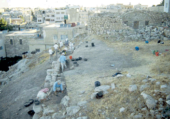 At the start of the 1998 season, five squares were opened along the crest of the west slope of the upper mound, immediately to the east of a large fortification wall that protruded above the tall surface. This area was designated Field B (
 Using the north-south east-west grid system established during the 1993 surface survey of Madaba, five 5 X 5 m excavation units (5M21U3, 5M21U4, 5M11A1, 5M11A2 and 5M11A3), or a total area of 125 sq m, were opened in 1998 (
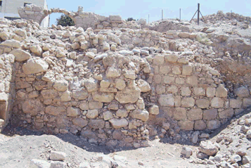 The large fortification wall separating Fields B and C represents the earliest structure uncovered thus far along the western slope of the upper mound (
 The construction sequence, best evidenced in Square 5M21U3 (
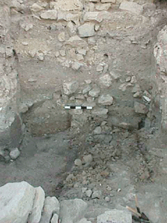 The probe also uncovered the corner of a structure constructed of unhewn stone, extending from the east balk of the square (
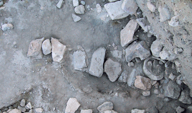 Since excavation of the Iron II strata in Field B had not yet reached occupational levels by the end of the 2000 field season, observations about the Iron Age ceramic industry must remain preliminary and tentative for the time being. Nevertheless, the post-abandonment deposits uncovered in Field B have produced a large volume of Iron II pottery, and it was decided that this material might be used to begin the process of classifying and characterizing the ceramic industry. To initiate this process, a corpus of pottery was drawn from a sequence of seven stratigraphically superimposed soil layers (or loci) in Square 5M11A1, which has produced the best preserved Iron Age sequence excavated thus far in Field B. The assemblage was collected systematically by means of a comprehensive screening regime, resulting in a total sherd count of 4,003 from the seven loci, with diagnostic rim sherds accounting for 311 of the total, or just under 10% of the assemblage. To establish a preliminary typology, the assemblage was sorted according to functional type (e.g. bowls, kraters, cooking pots, store jars, jugs, juglets and lamps), with metric attributes such as rim diameter providing secondary criteria. Macroscopic fabric data was also gathered from each vessel sherd to further aid in the characterization of this material. As illustrated in Figures
 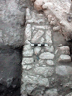 FP 5 was first delineated during the 1998 season. A single wall, made of heavily eroded ashlar blocks loosely arranged in a header and stretcher pattern ran across the western extent of Square 5M21U4 in a northeast-southwesterly direction. A clearly defined surface embedded with an intact tabun (or oven) and stone-lined pit sealed against this wall. By the end of the 1999 season, excavations had reached FP 5 levels in 5M21U2 and 5M21V3, including the northern extension of the wall uncovered in 1998, and two walls that abutted it from the east (
 The 1999 season also succeeded in uncovering a series of walls (shaded in red in
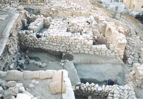 To the south, the large east-west wall, and its subsidiary wall, were abutted by a series of north-south running walls in Squares 5M11A2 and 5M11B1, effectively closing whatever passageway may have existed leading toward the gateway to the west in the earlier Field Phase. Two well-preserved walls uncovered during the 1999 season in 5M11B3, one faced on its eastern side with white plaster, also were assigned to FP 4. However, the founding levels of these walls were not reached by the end of the 1999 season, and therefore some uncertainty remains regarding their phasing.
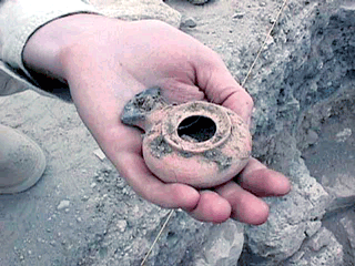 Analysis of the pottery and associated small finds from FPs 5 and 4 point to a Late Hellenistic (ca. 2nd to early 1st Centuries B.C.E.) date. One of the more defining characteristics of the FPs 5 and 4 assemblage is the total absence of the Nabataean painted wares so prevalent in the succeeding FPs 3 and 2. In addition to the presence of distinctive Hellenistic imports (such as lamps and amphora; see
 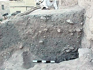 The final Field Phase preserved in Field B, excavated entirely during the 1998 and 1999 seasons, was represented by an arched wall line along the crest of the tell (running north-south through Squares 5M21U4, 5M11A1, 5M11A2, and 5M11A3), a stone-lined bin, segments of stone pavements, and several large ash-filled trash pits (
 Large samples of fauna were collected during each of the field seasons in Field B. The following report represents a preliminary analysis of the sample collected during the 1998 season. All soil deposits were submitted to a dry sieving regime, utilizing screens constructed with 1/4 inch hardware cloth. As a result we expect that large, medium and small mammals specimens are well represented in the collection. All of the bones were identified and labeled according to their square, locus and pail provenience, and assigned to one of four culturally distinct stratigraphic units and one mixed unit. These four cultural phases correspond to the Iron II, Late Hellenistic, Early Roman/Nabataean and Late Ottoman periods.
 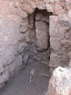 Evidence of renovations to the complex were visible in a number of rooms, most notably the vaulted chamber and the doorway to the unpaved room in Square 5L22Y2 (
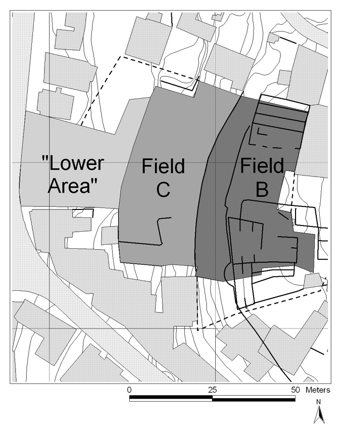